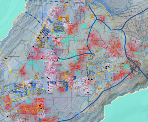
This map illustrates the nitrate concentrations in production wells. The contents of this analysis overlays the map of the Northern Guam Lens Aquifer (NGLA).
Updates
Last updated in 2021.
Downloadable Map Content
Click on one of the tabs below to view a list of shape files or raster files available for you to download.
Links to these files are currently under construction. Please check again later.
About
This map illustrates the nitrate concentrations in production wells. The contents of this analysis overlays the map of the Northern Guam Lens Aquifer (NGLA).