
Guam Public Laws 24-247 and 24-161
In 1998, the 24th Guam Legislature enacted Public Laws 24-247 and 24-161 as the Guam Hydrologic Survey (GHS) and the Comprehensive Water Monitoring Program (CWMP), respectively. These two laws were ratified in response to an El Niño event in 1998, resulting in a prolonged drought that advised water rationing practices. CWMP addresses the need for continued collection of hydrologic data and GHS to conduct more hydrologic and water resources research. WERI is charged with administering the annual legislative appropriations necessary to facilitate, direct, and implement the program’s primary objectives. Both programs are now integral to the WERI water resources research, information dissemination, education, and training mission.
The foresight of the Guam Legislature in creating these two vital programs deserves special mention. Through their efforts and continued support, WERI advances in consolidating and interpreting several essential water resource information, constructing hydrologic information for Guam, and revitalizing the USGS water resource monitoring program. Our understanding of the complex physical, chemical, and biological processes that influence Guam’s water resources has broadened, and the increase in graduate student research opportunities provided by the programs contributed to the number of highly trained water resource professionals in the island’s workforce.
Guam Hydrologic Survey Program
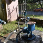
The purpose of GHS is to consolidate all of Guam’s available hydrological data gathered by local and federal government agencies and consultants, and to conduct research on water-related issues of local importance. GHS also funds a variety of water resource educational programs in various formats, including guest lectures and seminars at UOG and in the community, informational and training workshops for teachers and professionals from other government agencies, field trips and talks for students, and the publication and distribution of educational posters, maps, and fact sheets. In addition, GHS also funds research assistants and associates who engage in CWMP activities, including fieldwork with USGS’ observation well data collection, and phreatic groundwater and hydrologic data analyses.
For twenty-six years, WERI has continued to operate and administer the GHS Program. The GHS and CWMP Annual Reports are now available online on the GHS website.
WERI serves numerous island agency partners through the GHS Program, attending legislative hearings, providing research findings, sharing hydrologic and geologic maps, and advising on water resource concerns. Through the GHS Program, reliable research-based information can be achieved. Therefore, the Guam Legislature, Guam Environmental Protection Agency (GEPA), Guam Waterworks Authority (GWA), NAVFAC Marianas, and the Groundwater Resources Development Group (GWRDG) are more confident in determining management plans, actions, and regulations involving our water resources. WERI shared water research findings and advised agencies on wastewater issues, aquifer capacity, hydrogeologic assessments, surface hydrology, saltwater intrusion, and the new online data visualization products.
WERI provided GHS outreach to the Northern Guam Soil and Water Conservation District, GWA, the Legislature, Guam DOE, visiting universities, and the private sector with the Virtual Tour into the Northern Guam Lens Aquifer. Post social distancing protocols, in 2024 the GHS Program, with the services of Global Learning and Engagement (GLE UOG), WERI resumed the Northern Guam Lens Aquifer Virtual and Site Tour.
WERI continues to expand GHS interagency support through its online web products. Since developing the GHS website in 2016, WERI manages and produce new hydrologic reports, presentations, maps, and databases.
WERI continues to develop new online data visualization products—a new means of sharing hydrologic data through interactive maps and graphs, such as WERI WebMApps and MAppFx.
Comprehensive Water Monitoring Program (CWMP)
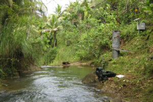
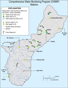
The CWMP is the core of essential water information, through approved measurements and analytic methods, the basis of hydrologic research interpretations. The CWMP was created to gather data on saltwater intrusion and water lens profiles in Guam’s sole source aquifer in the northern part of the island. Stream flow data and other parameters associated with surface waters are collected in the south. Moreover, the program collects rainfall data for hydrologic, meteorologic, and climatologic studies. These are essential for determining sustainability assessments and water supply capacities.
The CWMP rehabilitated data collection assets that fell into disrepair. CWMP allowed WERI to obtain services from USGS Pacific Island Water Science Center (PIWSC) to collect, organize, and manage hydrologic data from stream gages, rain gages, and observation wells. Government of Guam and USGS PIWSC funds the CWMP, restores the Federal/State Territory cost-sharing for continued hydrologic monitoring.
USGS PIWSC methods ensure that data are frequently and reliably collected, analyzed, and made widely available. Most data from USGS gages are readily accessible online. PIWSC collected hydrologic information for Guam are consolidated, quality is marked with provisional and approved, and made available online: http://hi.water.usgs.gov
CWMP data is analyzed and interpreted. GHS employs research assistants and research associates to organize, analyze, and interpret CWMP data. CWMP is essential to GHS projects that processes and analyzes and interprets the collected data.
GHS and CWMP Organization and Operations
The GHS program management, WERI Director, and Research Affiliate has reorganized the program management to include undergraduate research assistant support. The undergraduate research assistants slot to be filled will assist the program management, supporting web development as GHS mandate part of data repository, access, and distribution. The Research Affiliate will utilize an undergraduate research assistant to manage data and field assistance.
The Guam Hydrologic Survey office and computer hydro-laboratory at WERI had been remodeled to improve GHS functionality. Designated storage space and worktable has been built to organize and prepare valuable field equipment. Workstations and work space have been configured properly for research assistants in the environmental science program. A Guam geologic rock display section was built to improve collection and organization of the island’s rock inventory. This area is also designed as a small geology laboratory.
GHS provides limited stipends for research by graduate students working on their MS degree in Environmental Science and partial summer salaries to WERI faculty advising those students. It also pays for undergraduate field and lab assistants working on water resources projects on Guam, and the salary of one full-time Research Affiliate is charged with operating and managing WERI’s information database, the hydrology laboratory, and preparation and update of routine reports and presentations.
The program activities in this report begins with GHS Research Projects followed by CWMP Research Projects. The GHS section is organized into four sections: Northern Guam Lens Aquifer (NGLA) database, NGLA map series, Sustainable management, and Workshops.
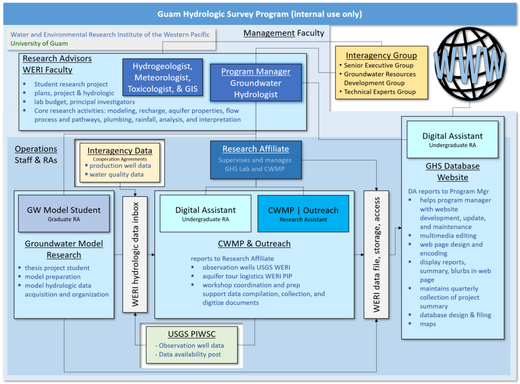
GHS and CWMP are organized by a program management team that involves the WERI Director and a support panel of WERI Faculty subject experts, the Program Coordinator, Operations Manager, and the Program Advisor. The WERI GHS and CWMP Programs continue to improve and may also change the internal organizational structure yearly to streamline operations management, processes, and product output. The organization is also crucial for determining the program’s resource requirements, project focus, and annual budget. The figure above is an internal WERI GHS and CWMP personnel and process diagram.
GHS analyzes water resource data for investigative research and the production of reports. WERI Faculty proposes GHS projects annually and supports a research assistant to conduct a GHS-related project. This opens opportunities for a research assistant to do a master’s thesis through UOG’s Environmental Science Program. GHS also has an Information Management team that oversees and develops both the WERI and GHS websites. The Operations Manager collects project summaries from faculty projects, CWMP projects and activities, and Information Management, and manages the organization and drafting of the GHS and CWMP Annual Reports.
Completed Projects
Comprehensive Guam and CNMI WERI Web-Based Rainfall Utility Data
Rainfall data for Rota, Tinian, Saipan and Guam were collected for archival and analysis. Rainfall data for Saipan presented several problems. Beginning in 2006, data for Saipan International Airport (SIA) archived at the National Climatic Data Center (NCDC) were ingested from the Automated Surface Observing System (ASOS). For many years (including the ASOS era), a NOAA-sponsored cooperative observer has been manually recording the daily (and monthly) rainfall at SIA. The ASOS rainfall data are always lower than the manually observed data (by 10- 30% on the monthly tallies). There is also a trend of increasing shortfall in the ASOS data. For Guam, a timeconsuming effort was undertaken to assemble a comprehensive archive of daily rainfall and temperature at Andersen Air Force Base (AAFB) and Guam International Airport Authority (GIAA). From the hundreds of thousands of hourly Meteorological Aerodrome Reports (METARs) at AAFB and GIAA during 1948 to present, the project PI filled in hundreds of missings days in the NCDC record for AAFB and GIAA. Problems in data archiving, effects of station moves, and failures of automated equipment were discovered. The complete daily and monthly climatic record for Guam and the CNMI is slowly being populated into a digital archive.
The enormity of the task (e.g., the need to cross-check official daily climate observations against the roughly 1 million hourly reports in the historical METAR record) was unanticipated and unabated. The problems discovered with the data are sufficient magnitude to substantially alter analyses of trends used for studies of climate change. The premier example of these is the completed archive for AAFB, in which hundreds of the daily climatic record and entries in the NCDC publicly available Global Historical Climatological Network (GHCN) climate data were cross-checked using a massive archive of over 1-million aviation hourly airfield reports. Similar comprehensive spreadsheets for climate data for other stations on Guam and for stations on the islands of the CNMI are in various stages of construction, with continual updating for current conditions.
Hydrological Features and Analysis in the Finegayan Area
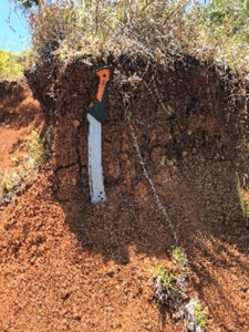
This project undertook an inventory of hydrogeological features in the Finegayan Basin, focusing on sinkholes, and exploring correlations between their proximities to relevant conditions, especially groundwater salinity, and how the proximities between features and conditions might relate to spatial and temporal variability of the conditions. The Hydrogeological features are identified and characterized from DEM and other mapped data, and include sinkholes, faults, changes in surface slope, and locations of groundwater zones (i.e. basal v. para-basal v. suprabasal). Conditions of interest include groundwater salinity (as conductivity or chloride), turbidity, pH, and hardness at production wells; daily, monthly and annual precipitation; land-use zoning, land cover and landcover change.
Analysis of salinity indicates that certain wells (F-10, F-6 and F-13) were consistently high in salinity, while other wells (F-19, F-4 and F-12) showed variable salinity. Additional work is required to explore the causes of variability, but one candidate hypothesis is proximity to concentrations of descending suprabasal water. Analyses of sinkholewell proximity suggest that the water quality of wells may correlate with proximity to sinkholes to some degree, e.g., some high-salinity wells have substantially developed sinkholes within 150 m of them, but additional work is needed to identify relevant sinkhole characteristics. Regression of well production against chloride concentration shows mixed results—positive correlations in some cases, negative correlations in other cases. Additional work is needed to examine the attributes of some of the historical data more closely, and explore the influence of other factors, such as well depth and efficiency.
Comprehensive Guam and CNMI WERI Web-Based Rainfall Utility Data
WERI research in Yap focused for several years on improving treatment in Yap’s municipal sewage treatment plant. Work in 2020 concentrated on continuation and maintenance of a low-cost, environmentally sustainable treatment for both raw sewage and the residual sludge. In the preceding few years, the project focused on pilot testing to ascertain the safety of making and using compost from the sludge. This year, the process was run at full scale in collaboration with the treatment plant operators and Yap Environmental Protection Agency (YEPA). E. coli was measured in compost test piles, and all were found safe as a Class A (i.e., good for direct human use) product. When the success was reported to the public upon YEPA’s certification of the results, the entire stock of sludge was immediately picked up by eager farmers and gardeners. This project is of manifest benefit to the local community in that not only is a hazardous waste product (i.e., raw municipal sludge) rendered safe, but moreover that it is converted into a valuable and sought-after resource (i.e., fertilizer). Due to the unexpected passing of the original principal investigator (Dr. Joe Rouse), Dr. Myeong-Ho Yeo took over this project in November 2019. Future phases of the project will focus on optimizing composting procedures, quality control and product safety, public education and outreach, and the supervision of the composting operation, which requires considerable manual labor for mixing, and careful control of temperature and humidity during composting to produce an effective and safe product.
Phase-II of N-baseline Data and Abatement Methods for the Northern Guam Lens Aquifer
Increasing nitrate in groundwater, and appropriate steps for mitigation are matters of increasing concern on Guam. Septic tanks are commonly used over the aquifer and their risks and contributions to the incidence of nitrate in groundwater are matters of debate. Understanding the occurrence and implications of nitrate begins with identifying its initial conditions and the processes that control its chemical evolution and fate within the aquifer.
Four active production wells were sampled, two (Y-3, Y 6) in sewered areas, and two (Y-15, Y 5) in nonsewered areas. A multi-probe analyzer in each well measured nitrate-N and ammonia-N, along with pH and temperature, every 2 weeks from July 2017 to April 2018. Wells Y-15, Y-3, and Y-5 averaged less than 3 ppm nitrate-N. Y-6, next to a home, averaged 3.6 ppm, rising to 4.4 ppm on rainy days. Effluent data from two septic tanks showed considerable variation, with total-N of 83 and 33 mg-N/L, ammonium of 70 and 29 mg-N/L, and nitrate of 0.1 and 0.1 mg-N/L, respectively, suggesting that no nitrogen cycling was occurring. Conversely, in the same area, two sampling events approximately one year apart, of one packaged treatment unit—which admittedly had not been well maintained— demonstrated total-N of 30 and 6.3 mg-N/L, ammonium of 3.8 and 0.1 mg-N/L, and nitrate of 22 and 3.2 mg- N/L, respectively, at the beginning and end of the sampling year. Hydrogeological features in the Finegayan Basin include sinkholes and faults over a karst limestone terrain. Salinity analyses were conducted on water quality records obtained from production well databases. Sinkhole proximities to production wells may correlate with well water quality, however, additional analyses is needed to further examine these influences.
These values suggest that considerable nitrification and, potentially, denitrification were occurring. This exploratory project indicates that the chemical environment in this aquifer is complex.
Development of GIS-based Imagery Database for Groundwater Recharge Areas and Key Reaches of Streams on Guam Phase II
To effectively manage a region’s water resources, water managers and water resources researchers must have accurate baseline data and subsequent time-series information on the geomorphological and ecological health of surface water streams and groundwater recharge areas. Recent advances in commercially available sUAS (Small Unmanned Aerial Systems) technology have made it possible to provide this baseline and follow-on time-series data with low cost, accurate, sub-meter-resolution aerial imagery. Phase II of this project began by installing at WERI an EOS Arrow Gold differential correction (RTK) base station and antenna system. The second step was calibration of the base station and extensive testing to confirm rover coordinates for ground control points match coordinates used in base maps available in WERI’s GIS system. The third step was development of georeferenced ortho-maps and digital elevation models of test areas in northern and southern Guam. The detailed georeferenced aerial data provide baseline information on location, size, and potential pollution sources in sinkholes located in the northern Guam groundwater recharge areas. In southern Guam, we can accurately plot stream cross-sections, determine erosion potential and possible sediment loading, and identify other sources of environmental contamination. The final step will be development of a data management scheme for the imagery and other digital data gathered by the project. The data management scheme will be compatible with WERI’s existing on-line water resources data retrieval system.
PFOS Trend Monitoring in Saipan Production Wells
Perfluoroalkyl substances (PFAS) have received attention as emerging contaminants in drinking water sources. The US EPA UCMR3 result revealed that drinking water contamination by PFAS in Saipan is more prevalent than in the Continental U.S. The Commonwealth Utilities Corporation (CUC), the public water and utility agency in Saipan, had collected water samples from 24 drinking water entry points. As the result of PFAS analysis, PFOS was detected in 5 wells and reservoirs. Power Web MApp of the resulting analysis of Nitrate-N in production wells. This Web MApp product is currently being used by Guam Waterworks Authority to strategically develop the wastewater management system above the aquifer.
In particular, the production well IF-208, located within the Saipan International Airport (SIA) has been contaminated with PFOS in the range of 4900 ~ 7000 ng/L, a value that is one hundred times higher than the US EPA’s lifetime health advisory concentration (70 ng/L).
As a preliminary step, 10 soil samples were collected for the analysis of UCMR3 PFAS. The Airport Rescue Firefighting Facility (ARFF) area in the SIA was selected as a sampling area because there was evidence of spraying firefighting foams for firefighter training. The result showed that all soil contained significant amounts of PFAS. The highest PFOS and PFOA concentrations detected were 6.57 ug/soil-kg, and 6.98 ug/soilkg, respectively.
Significant amounts of PFHpA, PFNA, and PFHxS were also detected. Concentrations of PFHpA, PFNA, and PFHxS ranged 0.16 – 10.40 ug/soil-kg, 1.77 – 7.78 ug/soil-kg and 1.06 – 4.26 ug/soil-kg. PFBS was not detected in all soil samples. Distribution of these species is complex and poorly understood. Further investigations will be conducted to characterize the degree and distribution of PFAS contamination in this area.
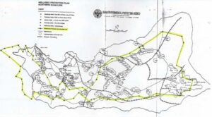
Hydrologic Spatial Analysis of Basins and Suspect Sinkholes in the Northern Guam Lens Aquifer
A concerning major pathway for contaminant transport into limestone aquifers is through sinkholes. The Northern Guam Lens Aquifer (NGLA) has a surface plateau formed from uplifted and tilted geologic formations of limestone bedrock. This aquifer is also the island’s vital source of fresh water. It has a deep vadose zone (80-120 m) that filters much of the percolating infiltrated rainfall. However, during storms that often bring intense rainfall, infiltration rate is exceeded, and surface runoff occurs. The porous karst terrain on the plateau has surface depressions in a mesh of enclosed basins, basins within basins, and cascading basins. These basins serve as sites where surface runoff may pond and serve as cumulative and secondary sources of contaminants into the catchment low points. Some of these surface depressions have turned out to be sinkholes (collapsed and doline) and fractures that conduct or drain large volumes of runoff into the freshwater aquifer. Proper land development must take into consideration the pathways in which anthropogenic contaminants may be transported to water sources and drawn up in near production well drawdown zones or in down gradient production wells.
Guam Environmental Protection Agency (GEPA) is keen on regulating development over hydrologically significant sinkholes, fractures, and surface depressions. They require hydrogeological assessment and site inspection in these sensitive areas. However, initial assessment via existing maps of closed contour depressions used to determine potential sinkholes were derived from old topography and has proven to have major inaccuracies and limitations. The development of a new map using the latest lidar based digital elevation (1 m raster resolution) and GIS hydrologic spatial analysis should greatly improve the island’s stormwater management practices over the aquifer.
The map analysis provided by this project provides an important aquifer map series that will be used to assess groundwater protection zones. The need for an improved sinkhole analysis has been an important concern discussed in the WERI Guam Advisory Council Meetings.
(GWA) Production-Well Rehabilitation Assessment: Lessons Learned Report & Manual for Well Exploration and Development
GWA operates about 120 production wells, of which about 100 are online at any given time. Over the past few years, GWA has undertaken a systematic rehabilitation program for its non-performing (closed) wells. Investigation of these closed production wells showed there are three main categories for why the closed wells originally failed: 1) deterioration due to age; 2) contamination of water at the site; and 3) historically poor performance.
Aging problems include broken or corroded well casing, stuck pumps from previous maintenance failures, and screen deteriorations. Contamination problems include saltwater contamination and the occurrence of contaminants originating from surface activities. The latter includes contamination by chlordane, PCEs and PFOS. Wells closed for chronic underperformance or mis-performance appear to have been installed in locations where geologic conditions produce large seasonal variations in local storage and water levels. Drilling of adjacent replacement wells showed that well performance can vary greatly between identical boreholes located only a few tens of feet from one another—reflecting the high local-scale heterogeneity in the hydraulic properties of the Northern Guam Lens Aquifer (NGLA). Well rehabilitation data are being collected to prepare a Lessons Learned Report & Manual for Well Exploration and Development. This report will help local drillers better manage site selection, well installation, preventive maintenance, and
Production Well Nitrate N-Trends in the Northern Guam Lens Aquifer
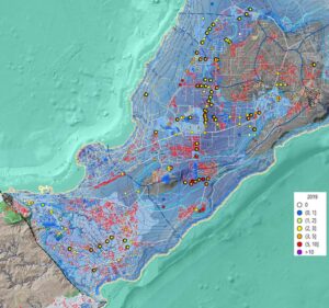
Increased development over Guam’s Principal Source Aquifer may be impacting the island’s major water source with wastewater. Data analysis of nitrates in production wells reveal that more than half of the wells over the NGLA have an increasing nitrate trend. Sewer main systems have lagged and may have deteriorated, and wells near increased density of non sewered homes seems to be impacted. GWA and GEPA are working closely with WERI, referring to the results of this project to strategically target areas that need immediate attention to reduce wastewater from entering the aquifer.
Nitrate-N concentration above 2 ppm in utility water suggests contamination from some combination of sewer line leakage, septic tank effluent, agricultural animal waste, or fertilizer runoff from farms or golf courses. Preliminary inquiries 20 years ago suggested that potential reasons for increasing amounts of nitrate-N in production wells included increased numbers and densities of septic tanks in nearby areas. In this study, a trend analysis of nitrate-N data from 146 production wells from 1978 to 2019 was conducted to document changes since the previous study and help to prioritize intervention. The construction of nitrate-N time-series for each well, along with map series showing nitrate-N concentrations over time in each of the production wells provide a means for assessing areas of concern and setting priorities for preventive and remedial actions. Results show that while initial records indicate background nitrate-N levels of about 2 ppm, concentrations have risen in 84 (58%) wells. Of these 84 wells, 66 (46%) exhibit steadily increasing trends across the entire record at values of 1.5 to 5.1 ppm, while 18 (12%) wells show increases up to about the year 2000, with the trend flattening thereafter to 2.9 to 5.4 ppm. Fifty-five wells (38%) exhibit no significant trend, and 7 (5%) show decreasing trends. Without interventions, nitrate-N concentrations are likely to rise in areas that see additional development. Results from this study may be used to inform effective management and regulation for aquifer protection.
Ongoing Research
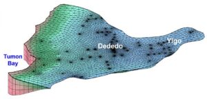
Development of the Groundwater Model of the Yigo-Tumon Basin, Northern Guam Lens Aquifer
Guam has plans for major island growth and expansion well within the next 10 years, requiring more water from its principal source— the Northern Guam Lens Aquifer (NGLA). Developers will be looking for groundwater models to test aquifer capacity and placement of additional wells. Reliable groundwater models are very useful for determining aquifer development strategies that include optimum production well configuration and sustainable management of water resource.
The Yigo-Tumon Basin, in the NGLA, is the most abundant source of utility water out of the 6 aquifer basins, where deep production wells extract about half of the total 42 MGD from the NGLA, which is about 90% of total water produced on the island. More than 20 years of NGLA research and data is available that can be used to develop a reliable groundwater model of the NGLA, starting with the Yigo-Tumon Basin.
A new addition to NGLA research in 2019 is the timeseries of phreatic profiles in three deep observation wells in this basin that present the spatially varied dynamic response to recharge, from which model results can be matched. And most recently accomplished, groundwater model assessment of the capacity of each basin’s “sweet spot,” the parabasal zone. Also, the advancement in groundwater modeling software and computer technology, integrating tested finite element code extensions (FEM Water), GIS capability, 3-D interface are available in Aquaveo® Groundwater Modeling Systems (GMS) that will be the selected model application, and that will run on WERI’s fast computer.
A Sustainable Plan for Stormwater management and Flooding at Garapan, Saipan
Guam has plans for major island growth and expansion well within the next 10 years, requiring more water from its principal source— the Northern Guam Lens Aquifer (NGLA). Developers will be looking for groundwater models to test aquifer capacity and placement of additional wells. Reliable groundwater models are very useful for determining aquifer development strategies that include optimum production well configuration and sustainable management of water resource.
The Yigo-Tumon Basin, in the NGLA, is the most abundant source of utility water out of the 6 aquifer basins, where deep production wells extract about half of the total 42 MGD from the NGLA, which is about 90% of total water produced on the island. More than 20 years of NGLA research and data is available that can be used to develop a reliable groundwater model of the NGLA, starting with the Yigo-Tumon Basin.
A new addition to NGLA research in 2019 is the timeseries of phreatic profiles in three deep observation wells in this basin that present the spatially varied dynamic response to recharge, from which model results can be matched. And most recently accomplished, groundwater model assessment of the capacity of each basin’s “sweet spot,” the parabasal zone. Also, the advancement in groundwater modeling software and computer technology, integrating tested finite element code extensions (FEM Water), GIS capability, 3-D interface are available in Aquaveo® Groundwater Modeling Systems (GMS) that will be the selected model application, and that will run on WERI’s fast computer.
Potential PFAS Contamination Sites Near the GWA Production Well A-25
Guam has plans for major island growth and expansion well within the next 10 years, requiring more water from its principal source— the Northern Guam Lens Aquifer (NGLA). Developers will be looking for groundwater models to test aquifer capacity and placement of additional wells. Reliable groundwater models are very useful for determining aquifer development strategies that include optimum production well configuration and sustainable management of water resource.
The Yigo-Tumon Basin, in the NGLA, is the most abundant source of utility water out of the 6 aquifer basins, where deep production wells extract about half of the total 42 MGD from the NGLA, which is about 90% of total water produced on the island. More than 20 years of NGLA research and data is available that can be used to develop a reliable groundwater model of the NGLA, starting with the Yigo-Tumon Basin.
A new addition to NGLA research in 2019 is the timeseries of phreatic profiles in three deep observation wells in this basin that present the spatially varied dynamic response to recharge, from which model results can be matched. And most recently accomplished, groundwater model assessment of the capacity of each basin’s “sweet spot,” the parabasal zone. Also, the advancement in groundwater modeling software and computer technology, integrating tested finite element code extensions (FEM Water), GIS capability, 3-D interface are available in Aquaveo® Groundwater Modeling Systems (GMS) that will be the selected model application, and that will run on WERI’s fast computer.
Hydrological Features and Analysis in the Finegayan Area
Guam has plans for major island growth and expansion well within the next 10 years, requiring more water from its principal source— the Northern Guam Lens Aquifer (NGLA). Developers will be looking for groundwater models to test aquifer capacity and placement of additional wells. Reliable groundwater models are very useful for determining aquifer development strategies that include optimum production well configuration and sustainable management of water resource.
The Yigo-Tumon Basin, in the NGLA, is the most abundant source of utility water out of the 6 aquifer basins, where deep production wells extract about half of the total 42 MGD from the NGLA, which is about 90% of total water produced on the island. More than 20 years of NGLA research and data is available that can be used to develop a reliable groundwater model of the NGLA, starting with the Yigo-Tumon Basin.
A new addition to NGLA research in 2019 is the timeseries of phreatic profiles in three deep observation wells in this basin that present the spatially varied dynamic response to recharge, from which model results can be matched. And most recently accomplished, groundwater model assessment of the capacity of each basin’s “sweet spot,” the parabasal zone. Also, the advancement in groundwater modeling software and computer technology, integrating tested finite element code extensions (FEM Water), GIS capability, 3-D interface are available in Aquaveo® Groundwater Modeling Systems (GMS) that will be the selected model application, and that will run on WERI’s fast computer.
Establishing Groundwater Protection Zones in Guam
Guam has plans for major island growth and expansion well within the next 10 years, requiring more water from its principal source— the Northern Guam Lens Aquifer (NGLA). Developers will be looking for groundwater models to test aquifer capacity and placement of additional wells. Reliable groundwater models are very useful for determining aquifer development strategies that include optimum production well configuration and sustainable management of water resource.
The Yigo-Tumon Basin, in the NGLA, is the most abundant source of utility water out of the 6 aquifer basins, where deep production wells extract about half of the total 42 MGD from the NGLA, which is about 90% of total water produced on the island. More than 20 years of NGLA research and data is available that can be used to develop a reliable groundwater model of the NGLA, starting with the Yigo-Tumon Basin.
A new addition to NGLA research in 2019 is the timeseries of phreatic profiles in three deep observation wells in this basin that present the spatially varied dynamic response to recharge, from which model results can be matched. And most recently accomplished, groundwater model assessment of the capacity of each basin’s “sweet spot,” the parabasal zone. Also, the advancement in groundwater modeling software and computer technology, integrating tested finite element code extensions (FEM Water), GIS capability, 3-D interface are available in Aquaveo® Groundwater Modeling Systems (GMS) that will be the selected model application, and that will run on WERI’s fast computer.
Northern Guam Lens Aquifer Monitoring System Expansion Rehabilitation Program
Guam has plans for major island growth and expansion well within the next 10 years, requiring more water from its principal source— the Northern Guam Lens Aquifer (NGLA). Developers will be looking for groundwater models to test aquifer capacity and placement of additional wells. Reliable groundwater models are very useful for determining aquifer development strategies that include optimum production well configuration and sustainable management of water resource.
The Yigo-Tumon Basin, in the NGLA, is the most abundant source of utility water out of the 6 aquifer basins, where deep production wells extract about half of the total 42 MGD from the NGLA, which is about 90% of total water produced on the island. More than 20 years of NGLA research and data is available that can be used to develop a reliable groundwater model of the NGLA, starting with the Yigo-Tumon Basin.
A new addition to NGLA research in 2019 is the timeseries of phreatic profiles in three deep observation wells in this basin that present the spatially varied dynamic response to recharge, from which model results can be matched. And most recently accomplished, groundwater model assessment of the capacity of each basin’s “sweet spot,” the parabasal zone. Also, the advancement in groundwater modeling software and computer technology, integrating tested finite element code extensions (FEM Water), GIS capability, 3-D interface are available in Aquaveo® Groundwater Modeling Systems (GMS) that will be the selected model application, and that will run on WERI’s fast computer.
Comprehensive Hydrological Database for Secure Water Resources in Tofol Watershed, Kosrae
Guam has plans for major island growth and expansion well within the next 10 years, requiring more water from its principal source— the Northern Guam Lens Aquifer (NGLA). Developers will be looking for groundwater models to test aquifer capacity and placement of additional wells. Reliable groundwater models are very useful for determining aquifer development strategies that include optimum production well configuration and sustainable management of water resource.
The Yigo-Tumon Basin, in the NGLA, is the most abundant source of utility water out of the 6 aquifer basins, where deep production wells extract about half of the total 42 MGD from the NGLA, which is about 90% of total water produced on the island. More than 20 years of NGLA research and data is available that can be used to develop a reliable groundwater model of the NGLA, starting with the Yigo-Tumon Basin.
A new addition to NGLA research in 2019 is the timeseries of phreatic profiles in three deep observation wells in this basin that present the spatially varied dynamic response to recharge, from which model results can be matched. And most recently accomplished, groundwater model assessment of the capacity of each basin’s “sweet spot,” the parabasal zone. Also, the advancement in groundwater modeling software and computer technology, integrating tested finite element code extensions (FEM Water), GIS capability, 3-D interface are available in Aquaveo® Groundwater Modeling Systems (GMS) that will be the selected model application, and that will run on WERI’s fast computer.
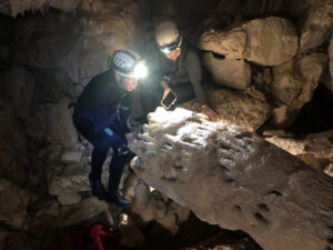
Hydrological Control on Submarine Groundwater Flow in Ayuyu Cave
Guam has plans for major island growth and expansion well within the next 10 years, requiring more water from its principal source— the Northern Guam Lens Aquifer (NGLA). Developers will be looking for groundwater models to test aquifer capacity and placement of additional wells. Reliable groundwater models are very useful for determining aquifer development strategies that include optimum production well configuration and sustainable management of water resource.
The Yigo-Tumon Basin, in the NGLA, is the most abundant source of utility water out of the 6 aquifer basins, where deep production wells extract about half of the total 42 MGD from the NGLA, which is about 90% of total water produced on the island. More than 20 years of NGLA research and data is available that can be used to develop a reliable groundwater model of the NGLA, starting with the Yigo-Tumon Basin.
A new addition to NGLA research in 2019 is the timeseries of phreatic profiles in three deep observation wells in this basin that present the spatially varied dynamic response to recharge, from which model results can be matched. And most recently accomplished, groundwater model assessment of the capacity of each basin’s “sweet spot,” the parabasal zone. Also, the advancement in groundwater modeling software and computer technology, integrating tested finite element code extensions (FEM Water), GIS capability, 3-D interface are available in Aquaveo® Groundwater Modeling Systems (GMS) that will be the selected model application, and that will run on WERI’s fast computer
Identifying, Analyzing and Mapping Submarines Groundwater Discharge (SDG) with a Thermal Infrared (TIR) Sensor and Unmanned Aerial Vehicle (UAV)

Guam has plans for major island growth and expansion well within the next 10 years, requiring more water from its principal source— the Northern Guam Lens Aquifer (NGLA). Developers will be looking for groundwater models to test aquifer capacity and placement of additional wells. Reliable groundwater models are very useful for determining aquifer development strategies that include optimum production well configuration and sustainable management of water resource.
The Yigo-Tumon Basin, in the NGLA, is the most abundant source of utility water out of the 6 aquifer basins, where deep production wells extract about half of the total 42 MGD from the NGLA, which is about 90% of total water produced on the island. More than 20 years of NGLA research and data is available that can be used to develop a reliable groundwater model of the NGLA, starting with the Yigo-Tumon Basin.
A new addition to NGLA research in 2019 is the timeseries of phreatic profiles in three deep observation wells in this basin that present the spatially varied dynamic response to recharge, from which model results can be matched. And most recently accomplished, groundwater model assessment of the capacity of each basin’s “sweet spot,” the parabasal zone. Also, the advancement in groundwater modeling software and computer technology, integrating tested finite element code extensions (FEM Water), GIS capability, 3-D interface are available in Aquaveo® Groundwater Modeling Systems (GMS) that will be the selected model application, and that will run on WERI’s fast computer
A Comprehensive Review and Consolidation of Unpublished WERI Research on the NGLA Response to Variations of Sea Level and Rainfall
Rainfall amounts on Guam are high. The average annual rainfall on the island is roughly 100 inches, with modest (10-15%) geographical variation (drier in the middle and on the central east coast, and wetter in the southern mountain region and in a stripe across the northern end). But, despite high average rainfall, there are large variations of rainfall at all time scales. Over the course of the year, there is typically a 6-month dry season during which only 30 inches of the annual 100 inches accrues. It is thought that very little of the dry season rainfall recharges the aquifer. The amount of annual rainfall also has large variation, primarily the result of forcing by the El Niño/Southern Oscillation (ENSO) phemomenon.
Annual rainfall amounts vary by a factor of three! (50 to 150 inches). Daily rainfall during a typhoon exceeds 7 inches in one hour and 30 inches in 24 hours.
In past WERI research efforts, evidence was found that on top of the immediate response of the water table to rainfall and variations to sea level, the water table of the NGLA responded at an 18-month lag to long-term surpluses and deficits of rainfall. An elegant method, outlined in 2009 (minimizing the hysteresis of modeled water table with respect to the observed water table), elucidated the response of the aquifer to rainfall input. The findings of this research were largely exploratory, with formal investigative follow-through pending. This project will consolidate and summarize these past findings with a formal rigor (data consolidation, updated data, further statistical analysis, clarification of the techniques, and a detailed discussion of the results).
Aerial Survey and Field Instrumentation for Investigation of Landslide Threat to a Tropical Watershed in Southern Guam
Rainfall amounts on Guam are high. The average annual rainfall on the island is roughly 100 inches, with modest (10-15%) geographical variation (drier in the middle and on the central east coast, and wetter in the southern mountain region and in a stripe across the northern end). But, despite high average rainfall, there are large variations of rainfall at all time scales. Over the course of the year, there is typically a 6-month dry season during which only 30 inches of the annual 100 inches accrues. It is thought that very little of the dry season rainfall recharges the aquifer. The amount of annual rainfall also has large variation, primarily the result of forcing by the El Niño/Southern Oscillation (ENSO) phemomenon.
Annual rainfall amounts vary by a factor of three! (50 to 150 inches). Daily rainfall during a typhoon exceeds 7 inches in one hour and 30 inches in 24 hours.
In past WERI research efforts, evidence was found that on top of the immediate response of the water table to rainfall and variations to sea level, the water table of the NGLA responded at an 18-month lag to long-term surpluses and deficits of rainfall. An elegant method, outlined in 2009 (minimizing the hysteresis of modeled water table with respect to the observed water table), elucidated the response of the aquifer to rainfall input. The findings of this research were largely exploratory, with formal investigative follow-through pending. This project will consolidate and summarize these past findings with a formal rigor (data consolidation, updated data, further statistical analysis, clarification of the techniques, and a detailed discussion of the results).
GHS Outreach and Education Programs
Digital Atlas of Chuuk - A Geospatial Map and Data Server for Resource Management
Chuuk Lagoon is one of the largest coral lagoons in the world. It is a semiatoll and its barrier reef encompasses 18 high islands, all but one of which are inhabited. There are also many small, low-lying coral islands, one of which is inhabited. Chuuk Lagoon is the political and economic center of Chuuk State, the central and most populated state of the Federated States of Micronesia (FSM). The state capital, Weno, located in Chuuk Lagoon, is the largest and most densely populated urban area in the FSM. Chuuk Lagoon also acts as the administrative center for many outlying atolls scattered in the surrounding open ocean and can, thus, be viewed as the hub of commercial activity and economic development for the entire region of the Central Caroline islands. In addition, Chuuk is a part of a Small Island Developing State (SIDS) whose many low-lying yet densely-populated areas are at great risk of natural disasters and effects of climate change and sealevel rise. Sustainable development and effective management of resources, especially in the context of improving resiliency to the effects of climate change and responding to the risk of natural disasters and ameliorating their effects, requires geospatial information of the physical, environmental, and anthropogenic components of the entire system. Such information must be accurate, up-to-date, mutually compatible, and readily available. Given the difficulties in locating and accessing such data in Micronesia, let alone verifying their quality and actually applying them in decision making, Chuuk has a great need for a unified, comprehensive, and user-friendly information management system.
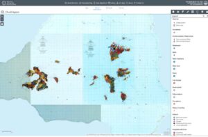
This geo-database for Chuuk will be established to incorporate all relevant physical, environmental, and infrastructural information and would include existing data (which would be inventoried and collected as part of this project) and any new data yet to be created, and become the mainstay for future collecting, digitizing, cataloguing, and distributing geospatial data on Chuuk. Therefore, the overall objective of the project proposed here is to create a robust, comprehensive, and versatile geospatial data server to support all geospatial aspects of planning, disaster risk reduction and emergency response, resource management, sustainable development, research and modeling, conservation, and education on Chuuk. Based on experiences from Guam and the FSM (specifically Pohnpei, and results of comparable projects there, we plan to call the product proposed here the “Digital Atlas of Chuuk.” It will be a counterpart of the intensively used and highly successful “Digital Atlas of Northern Guam” and “Digital Atlas of Southern Guam” created in several stages between 2009 and 2013, and a sister product of the “Digital Atlas of Pohnpei”, “Digital Atlas of Yap”, and “Digital Atlas of Kosrae”, which were developed by iREi and WERI from 2016 until 2019.
Guam Hydrologic Survey Website: Power Web MApps
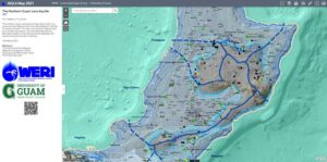
The Guam Hydrologic Survey website is developing interagency tools in Power Web MApps. Power Web MApps will be accessed online, via web links and QR code in the GHS website. More than five major Northern Guam Lens Aquifer (NGLA) and Guam maps have been developed thus far, built of multi-layer spatial information that will be useful to strategic development and protection of our most valuable resource, the NGLA. The Power Web MApps we develop is powered by ESRI®, Arc GIS Online, so the server system is robust and reliable. It opens up a panel on the left that describes the map, authors, and links to database and literature resources. The top right hand corner line a set of common useful and easy to use app widgets such as legend, layers, add layers, draw, ruler, and print. These Web MApps may be accessed on any web browser, on a desktop computer or handheld devices. More Power Web MApps are underway, and organized from their interagency data source. Three Web MApps are already being used now by our interagency partners: GWA, GEPA, GDOE, and Kumision I Fino CHamoru. We see this as one of the best way to share our research products and data to the world, empower our island regulators and developers with good information, and help us all to focus more on strategic and smart planning, execution, and management. With this new technology, now, our valuable resource is in all of our hands.
Workshop Series on Guam Groundwater Resources
The military buildup and ongoing economic growth anticipated on Guam over the next decade have raised concerns regarding sustainable management of Guam’s groundwater resources. Besides educating policymakers and agency heads, it is essential that island water resource professionals and educators be equipped with an accurate and up-to-date understanding of the island’s aquifer and the factors that must be considered to frame and implement sustainable management practices. Professional people in the water resources industry, from technicians to engineers, managers, agency heads, and policy-makers have extremely limited time to engage in professional development education opportunities. In FY 2019, WERI offered a two-day professional workshop on the Northern Guam Lens Aquifer (NGLA). It was held on 31 January and 7 February 2020. The affiliations of the participant included Guam EPA, Guam Bureau of Statistics and Plans, and private firms including EA Engineering, GHD, APDI, and AECOM.
The workshop covered WERI’s aquifer database containing hydrogeological, engineering, and management data. The salinity histories of wells and the relations to well operation, construction, and location were also addressed. The workshop also introduced ongoing studies of salinity, PFOS, and nitrogen analyses, hydrologic modeling of groundwater production capacity, and concepts for sustainable management of the NGLA. Nine WERI faculty taught a total of nine sessions of the workshop. Four one-day professional tours of the NGLA were planned in FY2019, but the tours were cancelled due to the COVID-19 pandemic.
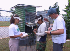
Sand Filtration Training for Yap State Public Service Corporation (YSPSC)
There are four independent water authorities in Yap: FSM-Yap State Public Service Corporation (YSPSC), Map Municipality Water Authority, Gagil-Tamil Water Authority, and Southern Water Authority. This four-day training incorporated inclass lectures and hands-on practice sessions as well as field trips. This training was the first training in which the different water authorities participated together. Operators from three water authorities, agents from Environmental Protection Agency (EPA), and the agents from the Project Management Office, Yap State, attended this training. Although the original training objective was to have been only slow sand filtration, participants advised the trainer that YSPSC has a rapid water treatment system, and asked for instruction and advice on basic hydraulics, techniques, and equipment operation. The trainer therefore adjusted the curriculum to provide information and tools appropriate for current local conditions and resources.
The training thus included the following information and more: 1) introduction to water system hydraulics, from water sources to storage tanks to customers; the parts of pumps and how best to operate and maintain them; and 3) how to operate and maintain disinfection systems. This spontaneous course of instruction was very well received, and now is in constant demand. The success of the training is explicitly documented in the survey collected at the end: 69% marked it excellent, and 16% scored it very good. Regarding how applicable the training is to their work, 58% of the attendees said very applicable, and 21%, applicable. A certificate of the completion was given to each attendee, and was uniformly highly appreciated.
Guam Water Kids
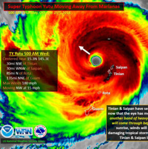
This year’s Guam Water Kids program continued to build on the success of this well-received collaborative effort between WERI and K-12 educators in the local community. Activities included 1) a Guam Water Kids service-learning collaboration with two Guam Department of Education (GDOE) central district schools: Tiyan High School and P.C. Lujan Elementary School; and 2) presentations and activities at the Pay-Less (groceries stores) Summer Camp and University of Guam’s 52nd Charter Day community outreach events. The primary goal achieved this year was building the partnership between officials and educators from GDOE, Tiyan, and P.C. Lujan Elementary School to implement the Guam Water Kids service-learning modules. Representatives from both schools acknowledged the limited off-theshelf resources and materials available to help visualize local geology, hydrology, and pollution sources in their classrooms. Teachers welcomed the program’s assistance to motivate students to be productive citizens and good stewards of the environment. Timely communication and logistic deliberate logistical planning aided in the Tiyan-P.C. Lujan service learning success in October 2019, despite Super Typhoon Hagibis’ passage over Guam the day before.
One notable success from this event is the quality of retention young students developed from the presentation of concise scientific explanations of local natural features and from subsequent hands-on activities. Several fifth-graders astounded the Tiyan High School ambassadors when they consistently answered content questions during the service learning visit. These students were also summer school participants received instruction over a span of three months—from a July summer presentation to the service learning presentation in October. WERI and Guam Water Kids are preparing training kits for educators and students using local rocks, gravels, and sands.
Guam Water Kids plans to expand its videos, free downloadable handouts and activities collection to include new footage from around the island.
Educational information for students can be found in the forms of narrated videos, flash cards, quizzes, and a link to the Guam Water Kids Facebook site for up-to-date media posts and announcements.
Facebook: https://www.facebook.com/guamwaterkids/
Advisory Council Meetings
WERI’s Three Advisory Councils. WERI maintains a separate advisory council for each of its three regional constituencies: 1) the US Territory of Guam, 2) the Federated States of Micronesia (FSM), and 3) the Commonwealth of the Northern Mariana Islands (CNMI).
Each council is built around a core of officials, managers, and technical experts from local agencies involved with water resources development, management, or regulation, who serve as more or less permanent members. Some have been formally appointed by their governments or agency heads. Others serve by invitation from WERI. The composition and appointment process for each council reflects the governmental and geographic conditions unique to each constituency.
The Guam Advisory Council core members include managers and technical experts from local agencies, and local offices of US federal agencies, including the local military civil engineering units and their contractors that deal with water resources. The core members of the councils for the CNMI and FSM include representatives from local government departments, as well as permanently-stationed employees of US federal agencies; United Nations, European Union and other international development aid agencies; Non-Governmental Organizations; and local colleges and schools.
WERI convened each council for a day-long virtual conference to review and update its agendas for research, information transfer, and educational projects. In addition to the core members, people invited to the meetings include government officials, private sector engineers and planners, educators, students, and other scientific and professional colleagues involved in ongoing projects and programs. The morning agenda includes presentations on recently completed projects and ongoing projects. Following lunch, there are plenary and focus-group discussions on critical needs, after which each participant fills out a survey regarding directions of ongoing projects and prospective future projects.
Meeting participants frequently observe that WERI Advisory Council meetings are the sole venue in which all of the water resources professionals on their island meet together in a single group. The meetings are thus valued as unique forums for professional information-sharing and networking. Throughout each year, WERI uses council mailing lists to provide updates and announcements for events of common interest, including WERI research presentations, professional workshops, and thesis defenses.


