Guam Hydrologic Survey
Guam Public Law 24-247 & 24-161
Guam Hydrologic Survey
Guam Public Law 24-247 & 24-161
Guam Hydrologic Survey GU PL 24-247 & 24-161
Type and hit Enter to search
Guam Hydrologic Survey
Guam Public Law 24-247 & 24-161
Guam Hydrologic Survey GU PL 24-247 & 24-161
Type and hit Enter to search
Guam Hydrologic Survey GU PL 24-247 & 24-161
Guam Hydrologic Survey GU PL 24-247 & 24-161
Guam Hydrologic Survey
Guam Public Law 24-247 & 24-161
Guam Hydrologic Survey GU PL 24-247 & 24-161
About Us
Mission Statement
The Guam Hydrologic Survey (GHS) and the Comprehensive Water Monitoring Program (CWMP) were created in 1998 by the 24th Guam Legislature under Public Laws No. 24-247 and 24-161, respectively. The Water and Environmental Research Institute (WERI) was charged with administering the annual legislative appropriations to drive these two programs and facilitate, direct, and implement their objectives. Both programs are now an integral component of water resources research, information dissemination, education and training on Guam.
Goals
The Guam Hydrologic Survey consolidates and archives new and historical hydrological data collected by local and federal government agencies and private consultants, and conducts research on water-related issues of local importance. GHS also funds a variety of water resource educational programs, including guest lectures and seminars at UOG and in the community, informational and training workshops for teachers and other professionals, field trips and talks for schoolchildren, and the publication and distribution of educational posters, maps, and fact sheets.
The Comprehensive Water Monitoring Program (CWMP) was created to collect data on saltwater intrusion and water lens thickness in Guam’s northern aquifer, and stream flow for surface waters in the south. The program builds on studies previously undertaken by the US Geological Survey (USGS) that had been abandoned in the 1990s because of a discontinuance of matching funds from the Government of Guam. The CWMP annual appropriations from the Guam legislature restored the program in 1998 and since then have facilitated the collaborative reinstatement of these studies with USGS under their 50-50 Federal/State-Territory cost-sharing program for water resource monitoring.
The foresight of the Guam Legislature in creating these two very important programs deserves special mention here. With the continued support of the Legislature, we now maintain several vital water resources databases for Guam and collect essential water resource data in collaboration with the USGS. Our understanding of the complex physical, chemical and biological processes that influence Guam’s water resources has broadened considerably and the increase in graduate student research opportunities has substantially added to the number of highly trained water resources professionals in the island’s technical work force.
Funding
Sustainable Management in Your Hands
The Guam Hydrologic Survey and Comprehensive Water Monitoring Program (GHS and CWMP), Guam Public Laws 24-247 and 24-161, respectively, were established to develop an inter-agency cooperation for gathering and publicly providing water and environmental information. The ultimate goal is to support our quest of determining sustainable development and management of our island’s most valuable renewable resource, water. The mandate intent is to form a network that will help us improve our understanding of our water resources through data collection, analysis, interpretation, recommendations, reports, and presentation in all efforts to determine its optimum development for sustainable utility. GHS and CWMP contains the island’s collection of water resource and related hydrologic and environmental information by way of an organized online database system. Read more >>
Get the PDFs
- Guam Hydrologic Survey – Guam Public Law 24-247
- Comprehensive Water Monitoring Program – Guam Public Law 24-161
- Sustainable Development and Management of Guam’s Groundwater: A Recommended Program – Executive Summary
GHS and CWMP Annual Reports
Water and Environmental Research Institute of the Western Pacific (WERI), University of Guam (UOG) is charged with administering the GHS and CWMP. Annual reports are prepared for the years denoted in the table below.
Below is also a list of WERI publications, conferences, productions, and presentations. The text in bold are sponsored by GHS.
Water and Environmental Research Institute of the Western Pacific (WERI), University of Guam (UOG), is charged with administering the GHS and CWMP. Annual reports are prepared for the years:
FY1998 Jenson and Jocson (1998) Hydrologic Data Collection on Guam: FY1998 Report, Technical Report No. 83
FY2019 · FY2018 · FY2017 · FY2016 · FY2015 · FY2014 · FY2013 · FY2012 · FY2011 · FY2010 · FY2009 · FY2008 · FY2007 · FY2006 · FY2005
WERI Publications, Conferences, Products, Presentations, and GHS sponsored research products – annual listing, 2020-1998.
| Title | Publication | Conference | Author | Year |
|---|---|---|---|
| Hydrogeological assessment of the Urban Combat Training Project Site, Anderson AFB, Guam, Final Draft for Comment | Research Corporation University of Guam (RCUOG) WERI Scientific Advisory Report (SAR) for Merrick and Company: 227 pp. | Jenson, J.W., Y.S. Kim, and N.C. Habana | 2020 |
| A hydrogeologic survey of Santa Rita Spring, Guam: engineering and design recommendations for rehabilitation | WERI Technical Report 172, 102 pp. | Bourke, P., J.W. Jenson, N.C. Habana, and M.A. Lander | 2020 |
| Development of a GIS based imagery database for groundwater recharge areas and key reaches of streams on Guam phase II | WERI Technical Report 171: 49 pp. | Habana, N.C., L.F. Heitz, and M. Ziobro | 2020 |
| Perfluoroalkyl Substances (PFAS) Concentrations in Water Resources of Guam | International Conference on Geological and Environmental Sustainability, Seoul, December 21, 2019 | Kim, Y.S., M.N. Duenas, N.C. Habana, R. Lohmann, and J. Becanova | 2019 |
| Toward a Sustainable Management Concept for Coastal and Island Aquifers | National Groundwater Association (NGWA), Groundwater Week, Summit Conference Sessions: Sustainability and Planning Session, Las Vegas Convention Center, 3-5 December. NGWA: https://ngwa.confex.com/ngwa/gw19/meetingapp.cgi/Paper/12869. | Jenson, J.W. and N.C. Habana | 2019 |
| Hydrogeologic Survey of Santa Rita Spring, Guam: Determination of its Natural Capacity and Development Options | NGWA, Groundwater Week, Summit Conference Sessions: Sustainability and Planning Session, Las Vegas Convention Center, 3-5 December. NGWA: https://ngwa.confex.com/ngwa/gw19/meetingapp.cgi/Paper/12886. | Bourke, P., J.W. Jenson, N.C. Habana, and M.A. Lander | 2019 |
| Dynamic Response of a Freshwater Lens to Natural Variations in Recharge | International Journal of Advances in Science Engineering and Technology, Vol. 7: 20-27. | Dougher, B., N.C. Habana, J.W. Jenson, M.A. Lander, and K. Ho | 2019 |
| Defining and evaluating production capacity for the Northern Guam Lens Aquifer | WERI Technical Report 170: 57 pp. | Superales, D.G., N.C. Habana, and J.W. Jenson | 2019 |
| Hydrogeologic assessment for closed-contour depressions identified in the J-0001B Finegayan Utilities and site improvements project | RCUOG WERI SAR for Granite-Obayashi a Joint Venture (GOJV): 200 pp. | Jenson, J.W., Y.S. Kim, and N.C. Habana | 2019 |
| Dynamic response of the freshwater lens to natural variations in recharge, Northern Guam Lens Aquifer | WERI Technical Report 168: 39 pp. | Dougher, B., N.C. Habana, J.W. Jenson, M.A. Lander, K. Ho., and G.C. Aguilar | 2019 |
| Geotechnical assessment of the NSSAR Site, Live-Fire Training Range Complex, Northwest Field, Andersen Air Force Base, Guam | RCUOG WERI SAR for Black Construction Corporation: 108 pp. | Jenson, J.W., Y.S. Kim, and N.C. Habana | 2019 |
| Hydrogeologic assessment of the suspect sinkhole area at AC15 NIC Site: J-001B Finegayan Utilities and Site Improvements Project, Phase 1, Marine Corps Activity Guam | RCUOG WERI SAR for GOJV: 74 pp. | Jenson, J.W., Y.S. Kim, and N.C. Habana | 2019 |
| Dynamic response of a freshwater lens to natural variations in recharge | Proceedings of 186th International Academy of Science, Technology, Engineering, and Management – International Conference on Environment and Natural Science, Seoul, 4-5 July. IASTEM, http://iastem.org. | Dougher, B., N.C. Habana, J.W. Jenson, and M.A. Lander | 2019 |
| Groundwater contamination by polyfluoroalkyl substances (PFAS) in Guam | Proceedings of 186th IASTEM International Conference, Seoul, 4-5 July. IASTEM, http://iastem.org | Kim, Y.S., M.A. Duenas, N.C. Habana, G.R.W. Denton, J.W. Jenson, and M.A. Lander | 2019 |
| Development of a GIS based imagery database for groundwater recharge areas and key reaches of streams on Guam | WERI Technical Report 169: 59 pp. | Habana, N.C., L.F. Heitz, and M. Ziobro | 2019 |
| Dynamic response of the freshwater lens to natural variations in recharge, Northern Guam Lens Aquifer, Yigo-Tumon Basin | NGWA, Groundwater Week, Poster Sessions, Las Vegas, 3-6 December. NGWA: https://ngwa.confex.com/ngwa/gw18/webprogram/Paper12197.html. | Dougher, B., N.C. Habana, J.W. Jenson, M.A. Lander, and K. Ho | 2018 |
| Defining and Evaluating Groundwater Production Capacity for an Island Aquifer: Production Well System in the Parabasal Zone, Northern Guam Lens Aquifer | NGWA, Groundwater Week, Poster Sessions, Las Vegas, 3-6 December. NGWA: https://ngwa.confex.com/ngwa/gw18/webprogram/Paper12153.html. | . 2018. Defining and Evaluating Groundwater Production Capacity for an Island Aquifer: Production Well | 2018 |
| Guam Water Resources Monitoring Program | NGWA, Groundwater Week, Poster Sessions, Las Vegas, 3-6 December. NGWA: https://ngwa.confex.com/ngwa/gw18/webprogram/Paper12199.html. | Bautista, K., J.W. Jenson, N.C. Habana, and Y.S. Kim | 2018 |
| The Northern Guam Lens Aquifer Map | NGWA, Groundwater Week, Poster Sessions, Las Vegas, 3-6 December. NGWA: https://ngwa.confex.com/ngwa/gw18/webprogram/Paper12200.html. | Habana, N.C., and J.W. Jenson | 2018 |
| Consideration Factors of Production-Well Rehabilitation Assessment on Guam | NGWA, Groundwater Week, Poster Sessions, Las Vegas, 3-6 December. NGWA: https://ngwa. confex.com/ngwa/gw18/webprogram/Paper12160.html. | Kim, Y.S., J.W. Jenson, and N.C. Habana | 2018 |
| Hydrogeological assessment: Live-Fire Training Range Complex, sinkhole, Northwest Field, Andersen Air Force Base, Guam | West Pacific Geoscience Consulting (WPGC) SAR for Black Construction Corporation 2018: 98 pp. | Jenson, J.W., Y.S. Kim, and N.C. Habana | 2018 |
| Perfluorooctane Sulfonate (PFOS): a contaminant of emerging concern in Guam’s groundwater | Proceedings of the 125th The Institute of Research Engineers and Scientists (The IRES) International Conference, Beijing, 29-30 June. The IRES, http://theires.org | Denton, G.R.W., C.M. Sian Denton, Y.S. Kim, J.W. Jenson, N.C. Habana, and M.A. Lander | 2018 |
| Terrain analysis and sinkhole reconnaissance: planned firing range, Northwest Field, Andersen Air Force Base, Guam (P735 Firing Range) | WPGC SAR for Duenas Camacho and Associates (DCA): 66 Pp. | Jenson, J.W., Y.S. Kim, and N.C. Habana | 2018 |
| Digital Atlas of Yap. In: Digital Atlas of Micronesia | Available at www.islandatlas.org. Island Research & Education Initiative (iREi) and Water and Environmental Research Institute of the Western Pacific (WERI). | Taborosi, D. and Rouse, J. | 2018 |
| Digital Atlas of Micronesia | Available at www.islandatlas.org. Island Research & Education Initiative (iREi) and Water and Environmental Research Institute of the Western Pacific (WERI). | Taborosi, D. et al. | 2018 |
| Developing public awareness of benefits of composting waste sludge in Yap | Island Sustainability Conference: Island Alliance for Sustainable Action. University of Guam, Center for Island Sustainability. Tumon, Guam; March 27 – 30, 2018 | Rouse, Joseph D., Hyun Jong Hahm | 2018 |
| Improvements to Sewage and Sludge Treatment Operations on the Island of Yap, FSM | 2018 Pacific Water Conference – Enhancing Hawai’i’s Water Environment. Hawai’i Water Environment Association & American Water Works Association. Honolulu, Hawaii; February 7 – 8, 2018 | Rouse, Joseph D., Hyun Jong Hahm | 2018 |
| NGLA Groundwater Model Explorations | Guam Advisory Council Meeting, November 9, 2017, Tumon, Guam | Superales, Daniel, Nathan C. Habana, Barry Kim, John Jenson, Stephen Gingerich | 2017 |
| Effect of Climate Variability on Soil Erosion, Land Slide | Asian Pacific Academy of Science, Education, Environmental Management. Abstract, Saipan, November 10, 2017 | Lander, Mark; Shahram, Khisrowpanah | 2017 |
| Guam Hydrologic Survey Workshop | September 11 & 18, 2017, WERI, University of Guam, Mangilao, Guam | Habana Nathan; John Jenson, Barry Kim, Mark Lander, Bekah Dougher, Erin Miller, Daniel Superales, and Joseph Rouse | 2017 |
| Executive Tour: Guam Power and Water Authority, Northern Guam Lens Aquifer Tour | June 6, 2017, University of Guam, Mangilao, Guam | Habana, Nathan; Barry Kim, John Jenson | 2017 |
| Guam Waterworks Authority and UOG EV-511 Students NGLA Tour, Conference on Island Sustainability, Northern Guam Lens Aquifer Tour | April 21, 2017, University of Guam, Mangilao, Guam | Habana, Nathan; John Jenson | 2017 |
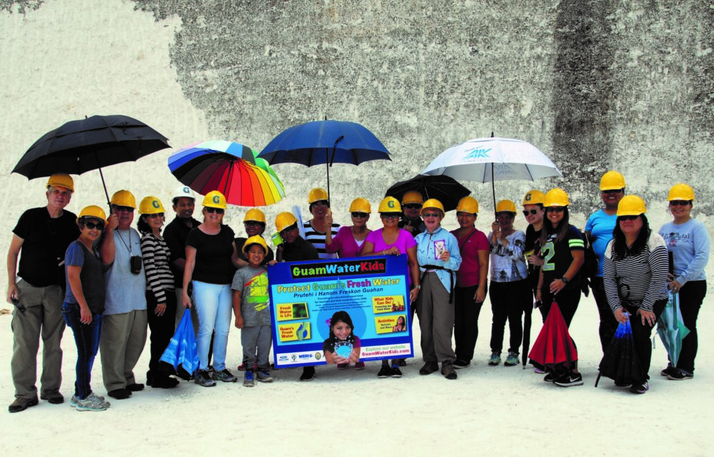
| Guam Water Kids and Guam Department of Education, Northern Guam Lends Aquifer Tour | April 13, 2017, University of Guam, Mangilao, Guam | Habana, Nathan; John Jenson | 2017 |
| Chloride and Production Trends | Guam Hydrologic Survey Workshop, Mangilao, Guam | Miller, Erin, Nathan Habana, Mark Lander, John Jenson | 2017 |
| Chloride and Production Trends | WERI Guam Annual Advisory Council Meeting, Water and Environmental Research Institute, University of Guam, Tumon, Guam | Miller, Erin, Nathan Habana, Mark Lander, John Jenson | 2017 |
| Chloride and Production Trends | In Abstracts and Program University of Guam Conference on Island Sustainability, University of Guam, Tumon, Guam 10 p. | Miller, Erin, Nathan Habana, Mark Lander, John Jenson | 2017 |
| NGLA Groundwater Model Explorations | Guam Hydrologic Survey Workshop September 11 & 18, 2017, Mangilao, Guam | Superales, Daniel, Nathan C. Habana, Barry Kim, John Jenson, Stephen Gingerich | 2017 |
| Evaluating Best-Practice Capacities for a Carbonate Island Karst Aquifer, Northern Guam Lens Aquifer, Guam, USA | NGWA Groundwater Summit 2017, Nashville, 4-7 December. NGWA: https://ngwa.confex.com/ngwa/2017gws/webprogram/Session12289.html. | Habana, N.C., J.W. Jenson, and S.B. Gingerich | 2017 |
| Expansion of Baseline Data for the Northern Guam Lens Aquifer and Evaluation of Innovative Technologies to Reduce Containment Input | WERI Annual Guam Advisory Council Meeting, Tumon, Guam | Habana, Nathan, Joseph Rouse, John Jenson | 2017 |
| Developing Stage-to-flow Relationships of the Toguan River, Guam | Asia-Pacific Academy of Science Conference, November 15 – 17, 2016, Saipan | Khosrowpanah, Sh. | 2016 |
| UOG Emerging School of Engineering: Training Tomorrow’s Engineers to Meet Today’s Community Needs | Asia Pacific Academy of Science Conference, November 15 – 17, 2016, Saipan | Khosrowpanah, Sh. | 2016 |
| Fish Sentinels Identify Mercury Hotspots in Saipan Lagoon | Asia-Pacific Academy of Science Conference, November 15 – 17, 2016, Saipan | Denton, G.R.W. | 2016 |
| Salinity in the Northern Guam Lens Aquifer: Natural and Human Factors | American Water Works Association, Hawaii Section, Western Pacific Subsection (AWWA HIWPS) Annual Conference, Tumon and Hagåtña, 11-12 April. AWWA-HIWPS: https://www.awwahiwps.org/2016-conference. | Simard, C., J.W. Jenson, M.A. Lander, M.Q. McDonald, and N.C. Habana | 2016 |
| A Digital Atlas of Northern Guam: www.hydroguam.net | Water & Environmental Research Institute of the Western Pacific, University of Guam, Mangilao, Guam | 2016 | |
| Water Resources on Outer-Lying Islands in Micronesia. Thesis. | Colorado State University, Fort Collins, CO. | Biekmann, A.M. | 2016 |
| Water resources on outer-lying islands in Micronesia | In J. Ramirez, abstract in: Proceeding of the XXXVI American Geophysical Union Hydrology Days, Fort Collins, CO. | Biekmann, A.M. and R.T. Bailey | 2016 |
| A Natural Resources Atlas of Southern Guam: www.hydroguam.net | Water & Environmental Research Institute of the Western Pacific, University of Guam, Mangilao, Guam | 2016 | |
| Digital Atlas of Phonpei, www.islands.fm/atlas | Water & Environmental Research Institute of the Western Pacific, University of Guam, Mangilao, Guam | Taborosi, D | 2016 |
| Pacific ENSO Update: A Quarterly Bulletin of the Pacific El Nino-Southern Oscillation Applications Climate (PEAC) Center | 3rd Quarter 2016, Vol. 22 No. 3. (www.weather.gov/media/peac/PEU/PEU_v22_n3.pdf) | M.A. Lander | 2016 |
| Exploring Best-Practice Capacities in the Northern Guam Lens Aquifer | 2nd Conference on Water Resource Sustainability Issues on Tropical Islands, Honolulu, 1-3 December. Water Resources Research Center (WRRI), University of Hawaii at Manoa: http://www.wrrc.hawaii.edu/2015conference/Program 11315.pdf | Habana, N.C., J.W. Jenson, and S.B. Gingerich | 2015 |
| Damaging Typhoons and Major Drought : The Ongoing and Forecast Effects of the 2015 El Nino in the Tropical Pacific | The Second Conference on Water Resource Sustainability Issues on Tropical Islands December 1 – 3, 2015 | Hilton Hawaiian Village | Honolulu, Hawaii | Lander, Mark A. | 2015 |
| Dieldrin: An Unregulated Drinking Water Contaminant of Potential Concern in Guam’s Groundwater | 2nd Conference on Water Resource Sustainability Issues on Tropical Islands, Honolulu, 1-3 December. Water Resources Research Center (WRRI), University of Hawaii at Manoa: http://www.wrrc.hawaii.edu/2015conference/Program11315.pdf | Denton, G.R.W., C. Sian Denton, and N.C. Habana | 2015 |
| Watershed Management: Ugum, Pit-Asan, and Geus Watershed | Second Conference on Water Resources Sustainability Issues on Tropical Islands. Abstracs. Honolulu, Hawaii, December 1 – 3 | Khosrowpanah, Sh., Mark Lander | 2015 |
| Terrain analysis and sinkhole reconnaissance: planned firing range area Northwest Field, Andersen Air Force Base, Guam | WPGC SAR for DCA | Jenson, J.W., and N.C. Habana | 2015 |
| Rainwater catchment system design using simulated future climate data | J. Hydrology 529, 1798-1809., 2015, Rainwater catchment system design using simulated future climate data. J. Hydrology 529, 1798-1809 | Wallace, C.D. and R.T. Bailey, and M. Arabi | 2015 |
| Estimation of future freshwater supply of Micronesian atoll islands using simulated climate data | In J. Ramirez, abstract in: Proceedings of the XXXV American Geophysical Union Hydrology Days, Fort Collins, CO. (Programs and Abstract) | Wallace, C.D. and R.T. Bailey | 2015 |
| Estimation of future freshwater lens volume of Micronesian Atoll islands | Conference of the American Water Resources Association, Tyson’s Corner, Virginia. (Program and Abstract) | Wallace, C.D. and R.T. Bailey | 2015 |
| Wallace, C.D., R.T. Bailey, and J.W. Jenson | Atoll Island Freshwater Resources: Modeling, Analysis, and Optimization | Water & Environmental Research Institute of the Western Pacific, Technical Report #155: 147 p. | 2015 |
| Studies on Enchancement of Sewage Treatment and Compositing of Sludge on Yap Island | Second Conference on Water Resources Sustainability Issues on Tropical Islands, Honolulu, Hawaii; December 1 – 3, 2015. (Conference Presentation with Abstract) | Rouse, Joseph D. | 2015 |
| Change Detection of Land Cover Change in Saipan | 37th Annual Research Conference, University of Guam, Mach 8, 2016, p3. | Wen, Y. and D. Chambers | 2015 |
| National Weather Service Forecast Office Guam and the University of Guam Water and Environmental Research Institute Typhoon Soudelor Wind Assessment for Saipan | American Meteorological Society 32nd Annual Conference on Hurricanes and Tropical Meteorology, Puerto Rico, April 2016. Online Proceedings. | Lander, Mark A. | 2015 |
| National Weather Service in Guam and the University of Guam Press Release: Typhoon Soudelor Wind Assessment for Saipan, CNMI | Press release to government agencies, local media, and public of Guam and the CNMI. Meteorological assessment of the intensity and damage caused by the passage of Typhoon Soudelor over Saipan on the night of 02 August 2015. | Guard, C.P., and Mark Lander | 2015 |
| Professional Field Trip of the Northern Guam Lens Aquifer | WERI, 33p. http://www.weriguam.org/ | Jenson, J.W., Danko, Taborosi | 2015 |
| Impact of WWII Dumpsites on Saipan (CNMI): Heavy Metal Status of Soils and Sediments | Journal of Waste Management and Research, (in review). | Denton, G.R.W. C.A. Emborski, R. Masga, J.A. Starmer | 2015 |
| Assessment of Turbidity in the Geus River Watershed in Southern Guam | WERI Technical Report No. 156, June 2015 | Khosrowpanah, S., Lander, M. A., Rouse, J.D., and Whitman, W.M.C. | 2015 |
| Exploring Best-Practice Capacities in the Northern Guam Lens Aquifer | AWWA-HIWPS Water and Wastewater Conference, Tumon, 13-14 April. AWWA-HIWPS: https://www.awwahiwps.org/2015-conference.html. | Habana, N.C., Jenson, J.W., and Gingerich, S.B. | 2015 |
| Guam International Airport, Stormwater infiltration analysis and recommendations in support of design of stormwater system improvements | WPGC and Allied Pacific Environmental Consulting SAR for Gutteridge Haskins & Davey: 46 pp. | Jenson, J.W., and N.C. Habana | 2015 |
| Testing the Strontium/Calcium Proxy for Sea Surface Temperature Reconstruction in the Coral Porites lutea, in Guam, Micronesia, University of Guam Marine Laboratory, Water & Environmental Research Institute of the Western Pacific. | UOGML Technical Reoport 152, WERI Technical Report 152 | McCutcheon, A. L., Raymundo, L. J., Jenson, J. W., Prouty, N. G., Lander, M. A., and Randall, R. H. | 2015 |
| Development of Environmentally Sustainable Methods for Treatment of Domestic Wastewater and Handling of Sewage Sludge on Yap Island | WERI Technical Report No. 153, February 2015 | Rouse, J.D. | 2015 |
| Salinity in the Northern Guam Lens Aquifer | Water & Environmental Research Institute of the Western Pacific, WERI Technical Report 143 | Simard, C. A., Jenson, J.W., Lander, M.A., Manzanilla, R.M., Superales, D.G., Habana, N.C. | 2015 |
| Analysis of Salinity in the Northern Guam Lens Aquifer, in Proceedings Proceedings of the 16th Symposium on the Geology of the Bahamas and other Carbonate Regions | Gerace Research Center, San Salvador Island, Bahamas, June 14-18, 2012 2015, in press | Simard, C. A., Jenson, J. W., and Lander, M. A. | 2015 |
| Treatment of Low-strength Municipal Wastewater Containing Phenanthrene Using Activated Sludge and Biofilm Process | Desalination and Water Treatment. 2015, pp. 1-11. | Sfaelou, S.; Papadimitriou, C.A.; Manariotis, I.D.; Rouse, J.D.; Vakros, J.; Karapanagioti, H.K. | 2015 |
| Atoll Island Freshwater Resources: Modeling, Analysis, and Optimization | WERI Technical Report #155, p. 147 p. | Wallace, C. D., Bailey, R. T., and Jenson, J. W. | 2015 |
| Land Cover Change in Saipan, CNMI from 1978 to 2009 | International Journal of Research In Earth and Environmental Sciences (IJREES), Volume 3: Issue 4, pp 6. | Wen, Y. and Chambers, D. | 2015 |
| Topography of the basement rock beneath the Northern Guam Lens Aquifer and its implications for groundwater exploration and development | WERI Technical Report 142: 72 pp. | Vann, D.T., V.M. Bendixson, D.F. Roff, C.A. Simard, R.M. Schumann, N.C. Habana, and J.W. Jenson | 2014 |
| The Northern Guam Lens Aquifer Database w/ accompanying CD | WERI Technical Report 141, 2nd Edition: 95 pp. | Bendixson, V.M., J.W. Jenson, and N.C. Habana | 2014 |
| Anthropogenic Biogeochemical Impacts on Coral Reefs in the Pacific Islands – An Overview | Deep-Sea Research II, 6: 5-12 | Morrison,R.J. , G.R.W. Denton, U. Bale Tamata and J. Grignon | 2014 |
| Regulatory Framework and Monitoring Strategies Adopted by GWA for the Sustainable Production of Safe Drinking Water from the Northern Guam Lens Aquifer | Regional Islands Sustainability Conference, Hyatt Regency, Tumon, Guam, April 15-16 2014 | Denton, G.R.W. and C.M. Denton | 2014 |
| Wind, Weather Watersheds and Water Quality: WERI Regional Research | Annual UOG Faculty Development Day, Hyatt Regency, Tumon, Guam February 21, 2014 | Denton, G.R.W. and J.W. Jenson | 2014 |
| Indoor Radon Levels and Lung Cancer on Guam | 35th Annual Research Conference, University of Guam, March 11, 2014 | Denton, G.R.W. and S. Namazi | 2014 |
| Artefatos militares e uso de cavernas durante a Segunda Guerra Mundial nas Ilhas Marianas, Pacífico Oeste (World War II artifacts and wartime use of caves in the Mariana Islands, Western Pacific) | Caderno de Geografia 24(42): 218-231. | Taboroši, D., Jenson, J. and Stafford, K.W. | 2014 |
| Utility of the Soft Coral, Sinularia polydactyla as a Biomonitor for Polychlorinated Biphenyls (PCBs) in Tropical Marine Waters | WERI Technical Report, No.151. 49 pp. plus appendices | Welch. P.M., Schupp, P. and G.R.W. Denton | 2014 |
| Influence of urban runoff, inappropriate waste disposal practices and World War II on the heavy metal status of sediments in the southern half of Saipan Lagoon, Saipan, CNMI | Marine Pollution Bulletin. 81(1):276-281 | Denton, G.R.W., Emborski, C.A., Habana, N.C. and Starmer, J.A. | 2014 |
| The Northern Guam Lens Aquifer Database | WERI Technical Report No. 141: 45 | Bendixson, V.M. | 2013 |
| Metal Deficiencies and Imbalances in Wetland Plants from a Manganese-Enriched Wetland in Southern Guam: A Possible Lytico-Bodig Connection? | APASEEM General Meeting, November 20-21, 2013, American Memorial Park Auditorium, Saipan | Denton, G.R.W. | 2013 |
| Coral Growth Calibration of the Sr/Ca Proxy for SST Reconstruction in Guam | 17th Biennial Ocean Sciences Meeting. Honolulu, Association for the Sciences of Limnology and Oceanography (ASLO), The Oceanography Society (TOS), and the American Geophysical Union (AGU) | McCutcheon, A., Raymundo, L., Prouty, N., Jenson, J., Lander, M. and Randall, R. | 2013 |
| Program & Abstracts: Evaluation of speleothem oxygen isotope fractionation from a tropical cave on the island of Guam | Fall Meeting, American Geophysical Union. San Francisco: December 9-13, 2013. | Moore, M., Hardt, B., Banner, J. and Jenson, J. | 2013 |
| Symposium Program and Abstracts: A hypothesis for carbonate island karst aquifer evolution from analysis of field observations in northern Guam, Mariana Islands | International Symposium on Hierarchial Flow Systems. Mádl-Szőnyi, J., Erőss, A., Mindszenenty, A. and Tóth, A. | Jenson, J.W., Taboroŝi, D., Rotzoll, K., Mylroie, J.E., and Gingerich, S.B. | 2013 |
| Meteorological Conditions Affecting Speleothem Paleoclimate Record in a Tropical Cave, Guam, Mariana Islands | National Speleological Society Convention. Shippensburg University, PA. | Mccann, S., Mylroie, J.E., Jenson, J.W. and Lander, M.A. | 2013 |
| VADOCHARGEN: a vadose flow and N-transport simulation model for the Northern Guam Lens Aquifer | International Journal of Engineering Science Technology and Research. Vol. 1(11):268-287 | Habana, N.C., J.W.L. Salvacion, J.W. Jenson, and J.D. Rouse | 2013 |
| GIS-based screening for cumulative and secondary impacts from development projects in northern Guam | WERI Technical Report No. 146, December 2013 | L. Muller, J.D. Rouse, S. Khosrowpanah | 2013 |
| Utility of the Brown Alga, Padina boryana, as a Biomonitor of Polychlorinated Biphenyls (PCBs) in Tropical Marine Waters: A Preliminary Assessment | WERI Technical Report. 34 pp. | Schaible, B.C. and G.R.W. Denton | 2013 |
| Caves and Karst Hydrology of the Mariana Island | Coastal Karst Landforms. Lace, M.J. and Mylroie, J.E. Dordrecht, Springer. 5: 277-298 | Stafford, K.W., Taboroši, D. and Jenson, J.W. | 2013 |
| Field observations of coastal discharge from an uplifted carbonate island aquifer, northern Guam, Mariana Islands: A descriptive geomorphic and hydrogeologic perspective | Journal of Coastal Research, v. 29, no. 4, p. 926-943 | Taborosi, D., Jenson, J.W., and Mylroie, J.E. | 2013 |
| VADOCHARGE-N: a Vadose Flow and N-Transport Simulation Model for the Northern Guam Lens Aquifer (in review) | 2013 International Conference on Sustainable Environmental Technologies, Mapúa Institute of Technology, Intramuros, Manila, Philippines | Habana, N.C., Salvacion, J.L., Jenson, J.W., and J.D. Rouse | 2013 |
| Utility of the Brown Alga, Padina boryana, as a Biomonitor for Polychlorinated Biphenyls (PCBs) in Tropical Marine Waters: A Preliminary Assessment | WERI Technical Report. 34 pp. | Schaible, B.C. and G.R.W. Denton | 2013 |
| Analysis of Salinity in the Northern Guam Lens Aquifer (in review) | In: Savarese, M., Glumac, B. (Eds.), 16th Symposium on the Geology of the Bahamas and Similar Regions, Gerace Research Center, San Salvador Island, Bahamas | Simard, C.A., Jenson, J.W., Lander, M.A. | 2013 |
| Watershed Management: Ugum and Piti-Asan Watersheds | Presented at 27th Pacific Islands Environment Conference, Guam, June 26-28, 2013 | Sh. Khosrowpanah | 2013 |
| VADOCHARGE-N: Deep Karst Vadose Flow and N Transport Simulation Model for the Northern Guam Lens Aquifer | 27th Pacific Islands Environment Conference, Tumon, 26-28 June. Guam EPA: https://issuu.com/guamepa/docs/piec_conferencebrochure/17 | Habana, N.C., J.W.L. Salvacion, J.W. Jenson, J.D. Rouse, and L.F. Heitz | 2013 |
| New Insights and Questions from Exploratory Drilling in the Northern Guam Lens Aquifer | 16th Symposium of the Geolgy of the Bahamas and other Carbonate Regions, Gerace Research Center, San Salvador Island, Bahamas | Jenson, J., Roff, D., Bendixson, V., Hylton, T., Simard, C. | 2012 |
| Continuing Calibration and Application of Luom in the Southern Guam Watersheds Not Covered in the Preceding Project | Water and Environmental Research Institute (WERI) Technical Report, No. 131, 68 pp. | Luo, Q.C., Khosrowpanah, S. | 2012 |
| Evidence of the Sea-level Change Since MIS 5e on Guam | Tropical West Pacific, NSF Workshop: Sea Level Changes Into MIS 5: From Observations to Predictions, April 10-14, 2012, Palma de Mallorca, Mallorca, Spain | Miklavič, B., Mylroie, J.E., Jenson, J.W., Randall, R.H., Banner, J.L., Partin, J.W. | 2012 |
| Denudation of Eogenetic Limestone During the Last Glacial Cycle in a Tropical Environment | 20th International Karstological School “Classical Karst”, Karst forms and Processes; 18th to 23rd June, 2012; Karst Research Institute, Postojna, Slovenia | Miklavič, B., Mylroie, J.E., Jenson, J.W., Randall, R.H., Zabukovec Logar, N., Taboroši, D. | 2012 |
| Relationship between Modern Rainfall Variability, Cave Dripwater and Stalagmite Geochemistry in Guam, USA | Geochemisty, Geophysics, Geosystems, 13 (3): 1-17 | Partin, J.W., Jenson, J.W., Banner, J.L.,. Quinn, T.M.,. Taylor, F.W., Sinclair, D., Hardt, B. Lander, M.A., Bell, T., Miklavič, B.,. Jocson, J.M.U., and Taboroši, T. | 2012 |
| Magnesium and Strontium Systematics in Tropical Speleothems from the Western Pacific | Chemical Geology, v 294-295: 1-17 | Sinclair, D., Banner, J.L., Taylor, F.W., Partin, J.W., Jenson, J.W., Mylroie, J.E., Goddard, E., Quinn, T.M., Jocson, J.M.J., and Miklavič, B. | 2012 |
| Analysis of Salinity in the Northern Guam Lens Aquifer, MS Thesis, University of Guam, Mangilao, Guam, 84 pp. | Simard, C.A. | 2012 | |
| Salinity Trends in the Northern Guam Lens Aquifer | 16th Symposium of the Geolgy of the Bahamas and other Carbonate Regions, Gerace Research Center, San Salvador Island, Bahamas | Simard, C., Jenson, J.W., Lander, M.A. | 2012 |
| Pneumatic Underwater Drill for Extracting Coral Cores | Water and Environmental Research Institute (WERI) Technical Report, No. 135: 18 pp. | Bell, T., Endo, T., Jenson, J.W., Bell, R., and Lander, M.A. | 2011 |
| Coral and Speleothem in situ Monitoring and Geochemical Analysis: Guam, Mariana Islands, USA | Water and Environmental Research Institute (WERI) Technical Report, No. 136: 70 pp. | Bell, T., Jenson, J.W., Lander, M.A., Randall, R.H., Partin, J.W., Hardt, B.F., and Banner, J.L. | 2011 |
| A Retrospective Analysis of Water Quality Data for Chemicals of Concern in Guam’s Groundwater: Emerging Trends and Future Concerns | Abstract, 14-16 November, Water Resources Research Center, University of Hawaii at Manoa, National Institutes for Water Resources, Honolulu, HI. | Denton, G.R.W. and Sian-Denton, C.M. | 2011 |
| Vadose Flow in the Northern Guam Lens Aquifer, Water Resources Sustainability Issues on Tropical Islands | Abstract, 14-16 November, Water Resources Research Center, University of Hawaii at Manoa, National Institutes for Water Resources, Honolulu, HI. | Jenson, J.W., Lander, M.A., Randall, R.H. | |
| Spatio-temporal Dynamics of Badlands in Southern Guam: A Case Study of Selected Sites | Water and Environmental Research Institute (WERI) Technical Report, No. 133, 90 pp. | Kottermair, M., Golabi, M., Khosrowpanah S. and Wen, Y. | 2011 |
| Relationship between Rainfall Variability, Cave Dripwater and Stalagmite Geochemistry in Guam, USA | Earth and Planetary Science Letters (in press) | Partin, J.W., Jenson, J.W., Banner, J.L., Quinn, T.M., Taylor, F.W., Sinclair, D., Lander, M.A., Bell, T., Miklavič, B., Jocson, J.M.U., Hardt, B., and Taboroši, D. | 2011 |
| Magnesium and Strontium Systematics in Tropical Speleothems from the Western Pacific | Chemical Geology (in press) | Sinclair, D., Banner, J.L., Taylor, F.W., Partin, J.W., Jenson, J.W., Mylroie, J.E., Goddard, E., Quinn, T.M., Jocson, J.M.U., and Miklavič, B. | 2011 |
| Magnesium and Strontium Systematics in West Pacific | Speleothems Quatenary Science Reviews (in press) | Sinclair, D., Banner, J.L., Taylor, F.W., Partin, J.W., Jenson, J.W., Mylroie, J.E., Goddard, E., Quinn, T.M., and Jocson, J.M.U. | 2011 |
| Impacts of Human Activities on Groundwater Quality in Guam, Mariana Islands | International Journal of Environmental, Cultural, Economic and Social Sustainability, 7 (5): 243-256 | Wen, Y. | 2011 |
| Land Cover Change of Watersheds in Southern Guam from 1973 to 2001 | Environmental Monitoring and Assessment, 179 (1-4): 521–529 (DOI 10.1007/s10661-010-1760-5) | Wen, Y., Khosrowpanah, S., and Heitz, L. | 2011 |
| Application of Multi-temporal and Multi-source Data for Land Cover Change Detection in Guam, USA | Proceedings of the 19th International Conference on GeoInformatics, June 24-26, 2011, Shanghai, China, published in IEEE Xplore in August, 2011 (DOI: 10.1109/GeoInformatics.2011.5981058, and Print ISBN:978-1-61284-849-5) | Wen, Y. | 2011 |
| Groundwater Monitoring on Guam (2010): Management Responses to Recent Water Quality Violations | Journal of Groundwater Monitoring and Remediation Spring 2010: 127-133 | Denton, G.R.W. and Sian-Denton C.M. | 2010 |
| Background Fluorescence in Guam’s Coastal Waters | Proceedings American Water Resources Association (AWRA) 2010 International Specialty Conference & 8th Caribbean Islands Water Resources Congress on Tropical Hydrology and Sustainable Water Resources in a Changing Climate, August 30 – September 1, 2010, San Juan, Puerto Rico. American Water Resources Association. | Hoffman, S.M., J.W. Jenson, G.R.W. Denton, D.C. Moran and L.L. Vacher | 2010 |
| Spatial Distribution of Badlands in the Ugum Watershed: Characterization and Temporal Analysis | Water and Environmental Research Institute (WERI) Technical Report, No. 126: 29 pp | Khosrowpanah, S., Y. Wen, and M. Kottermair | 2010 |
| Developing the LUOM in Southern Guam Watersheds | Proceedings of 4th International Workshop on Catchment-Scale Hydrological Modeling and Data Assimilation, Lhasa, China, 21-23 July 2010 | Luo, Q.C. and S. Khosrowpanah | 2010 |
| Calibration and Application of LUOM in Southern Guam Watersheds With and Without Flow Data | Water and Environmental Research Institute (WERI) Technical Report, No. 128: 87 | Luo, Q.C., and S. Khosrowpanah | 2010 |
| Interglacial Limestone and its Geomorphic Features on Guam: Implications for Relative Sea Level Changend Flank Margin Cave Formation | In: Gamble, D.W., ed., 15th Symposium of the Geolgy of the Bahamas and other Carbonate Regions: Gerace Research Center, San Salvador Island, Bahamas (in press) | Miklavič, B., Mylroie, J.E., Jenson, J.W., Randall, R.H., Banner, J.L., and Partin, J.W. | 2010 |
| Land Cover Change of Coastal Watersheds in Southern Guam from 1973 to 2001 | Environmental Monitoring and Assessment (in press) | Wen, Y. | 2010 |
| Vadose Flow Synthesis for the Northern Guam Lens Aquifer | Water and Environmental Research Institute (WERI) Technical Report, No. 127: 223 pp. | Habana, N., L.F. Heitz, A.E. Olsen and J.W Jenson | 2009 |
| Developing the LUOM in southern Guam watersheds without flow data | Proceedings of AWRA 2009 Annual Water Resources Conference, Seattle, Washington, November 9-12, 2009 | Luo, Q. C. and S. Khosrowpanah | 2009 |
| The Post-1997 El Niño Sea-Level Highstand in Micronesia: A Bona Fide Climatic “Hockey Stick” (in prep) | Lander, M.A. and Jenson, J.W. | 2009 | |
| Speleothem Evidence for Global Changes in Atmospheric Circulation During the Early-Mid Holocene | Quaternary Science Reviews. (in review) | Sinclair, D.J., Taylor, F.W., Banner, J.L., Jenson, J.W., Mylroie, J.E., Goddard, E. and Quinn, T.M. | 2009 |
| Impact of a Rudimentary Landfill on the Trace Metal Status of Pago Bay, Guam | Marine Pollution Bulletin, 58: 150-162 | Denton, G.R.W. and R.J. Morrison | 2008 |
| Solid Waste Disposal on Guam: Impact of an Unsanitary Landfill on the Heavy Metal Status of Adjacent Community Representatives | In: Wang, Y. et al. (Eds.). Progress in Environmental Science and Technology, vol 1. Science Press, Beijing, pp 1169-1176 | Denton, G.R.W., M.C. Olsen and Y. Wen | 2007 |
| A Qualitative Baseline Study of Background Fluorescence in Guam’s Groundwater | Water and Environmental Research Institute (WERI) Technical Report 57 pp. | Hoffman, S.M., J.W. Jenson, D. Moran, G.R.W Denton, H.R. Wood and L. Vacher | 2007 |
| Developing a GIS-Based Soil Erosion Potential Model of the Ugum Watershed | Water and Environmental Research Institute (WERI) Technical Report No. 117. 98 pp | Khosrowpanah, S., L.F. Heitz, Y. Wen and M. Park | 2007 |
| Analysis of the Dynamic Responses of the Northern Guam Lens Aquifer to Sea Level Change and Recharge | Water and Environmental Research Institute (WERI) Technical Report No. 118, 47 pp. | Wuerch, H.V., B.C. Cruz, A.E. Olsen | 2007 |
| Impact of Metal Enriched leachate from Ordot Dump on the Heavy Metal Status of Biotic and Abiotic Components in Pago Bay | Water and Environmental Research Institute (WERI) Technical Report No. 113, 63 pp. | Denton, G.R.W., W.C. Kelly III, H.R. Wood and Y. Wen | 2006 |
| Karst features of Guam, Mariana Island, Micronesica, 38: 17-46 | Taboroši, D., J.W. Jenson J.E. Mylroie | 2006 | |
| Environmental Assessment for Non-Point Sources of Pollution for Ugum Watershed | Water and Environmental Research Institute (WERI) Technical Report No. 109, 53 pp. | Khosrowpanah, S. and J. Jocson | 2005 |
| Karst of the Mariana Islands: The Interaction of Tectonics, Glacio-eustasy and Fresh-water/Sea-water mixing in Island Carbonates | GSA Special Paper 404. Proceedings of the Geological Society of America, pp. 129-138 | Jenson, J.W., T.M. Keel, J.E. Mylroie, J.R. Mylroie, K.W. Stafford, D. Taboroši, and C. Wexel | 2004 |
| Karst features of Guam, Mariana Island | Water and Environmental Research Institute (WERI) Technical Report No. 104, 26 pp. | Taboroši, D., J.W. Jenson and J.E. Mylroie | 2004 |
| Karren Features in Island Karst: Guam, Mariana Islands | Zeischrift fur Geomopholigie, 48: 369-389 | Taboroši, D., J.W. Jenson and J.E. Mylroie | 2004 |
| Dye Trace of Groundwater Flow from Guam International Airport and Harmon Sink to Agana Bay and Tumon Bay, Guam | Water and Environmental Research Institute (WERI) Technical Report No. 97, 32 pp. | Moran, D. C. and J.W. Jenson | 2004 |
| The Use of Water Temperature to Characterize Groundwater Discharge of a Coastal Fracture on Guam, U.S.A. | Journal of Coastal Research, 19: 462-471 | Gamble, D. W., D. Taboroši, J.E. Mylroie, J.W. Jenson, J.L. Carew, J.M.U. Jocson, J.R. Mylroie and D.T. Vann | 2003 |
| Chloride History and Trends of Water Production Wells in the Northern Guam Aquifer | Water and Environmental Research Institute (WERI) Technical Report No. 98, 64 pp. | Quenga McDonald, M. and J.W. Jenson | 2003 |
| Zones of Enhanced Dissolution and Associated Cave Morphology in an Uplifted Carbonate Island Karst Aquifer, Northern Guam, Mariana Islands | Speleogenesis and Evolution of Karst Aquifers, 1: (4), 16 pp. | Taboroši, D., J.W. Jenson and J.E. Mylroie | 2003 |
| Recharge and Aquifer Response: Northern Guam Lens Aquifer, Guam, Mariana Islands | Journal of Hydrology, 260: 231-254 | Jocson, J.M.U., J.W. Jenson and D.N. Contractor | 2002 |
| Nitrate-Nitrogen Concentrations in the Northern Guam Lens and Potential Nitrogen Sources | Water and Environmental Research Institute (WERI) Technical Report No. 95, 37 pp. | Quenga McDonald, M. | 2002 |
| Responses of Well Water Levels on Northern Guam to Variations of Rainfall and Sea Level | Water and Environmental Research Institute (WERI) Technical Report No. 94, 36 pp. | Lander, M.A., J.W. Jenson and C. Beausoliel | 2001 |
| Karst Features of Guam | Journal of Cave and Karst Studies, 63: 9-22. | 2001 | |
| Simulated Effect of Vadose Infiltration on Water Levels in the Northern Guam Lens Aquifer | Water and Environmental Research Institute (WERI) Technical Report No. 90, 18 pp. | Contractor, D.N. and J.W. Jenson | 1999 |
| Numerical Modeling and Field Investigations of Infiltration, Recharge, and Discharge in the Northern Guam Lens Aquifer | Water and Environmental Research Institute (WERI) Technical Report No.88, 22 pp. | Jocson, J.M.U., J.W. Jenson, and D.N. Contractor | 1999 |
| Karst Geology and Hydrology of Guam: A Preliminary Report | Water and Environmental Research Institute (WERI) Technical Report No. 89, 32 pp. | Mylroie, J.L. and J.W. Jenson, J.M.U. Jocson and M.A. Lander | 1999 |
| Hydrologic Data Collection for Guam | Water and Environmental Research Institute (WERI) Technical Report No. 83, 46 pp. | Jenson, J.W. and J.M.U. Jocson | 1998 |
Cooperators and Contributors
WERI is also a member of the local water resource interagency organization called the Technical Experts Group (TEG) and the Groundwater Resource Development Group (GWRDG) establish by the 16 July 2010 Memorandum of Understanding between the US Navy and Guam Waterworks Authority (Appendix I). The MOU provides an additional venue for meeting the GHS and CWMP mandates to “establish a direct working relationship with each organization collecting hydrologic data important to Guam, and maintain a permanent flow of new data from each organization to keep the data library up to date.”
Local and federal agencies that are party to or affected by the MOU include Guam Waterworks Authority, Guam Environmental Protection Agency, CUC, US Navy (NAVFACMAR), USAF (36 CES), and USGS. Interagency groups also include private consultants: Duenas Camacho and Associates, Allied Pacific Environmental Consultant (APEC), EA Engineering, Brown and Caldwell, and AECOM.
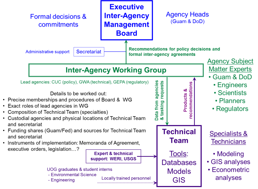
Meetings are organized and held quarterly at Guam Waterworks Authority (Gloria B. Nelson Public Service Building), Fadian. Current discussion is the expansion of monitoring (observation) wells, see details in CWMP Research Projects section. The interagency group organization, formed of three groups: executive, working, working group, and the technical team (See the GHS and GWRDG organization chart).
The inter-agency group meets quarterly to discuss concerns, pool resources, share ideas, provide update, consult, and gain professional acquaintance and partnerships. Here is a list of agencies in attendance:
Government of Guam
- GWA – Guam Waterworks Authority
- GEPA – Guam Environmental Protection Agency
- GCUC – Guam Consolidated Commission on Utilities
- GBSP – Guam Bureau of Statistics and Plans
- GDPW – Guam Department of Public Works
- GPUC – Guam Public Utilities Commission
- NGSWCD – Northern Guam Soil and Water Conservation District
- UOG – University of Guam
- WERI – Water & Environmental Research Institute of the Western Pacific
US - Federal
- USGS PIWSC – US Geologic Survey: Pacific Islands Water Science Center
- NAVFAC Marianas – Naval Facility Command Marianas, US Navy, Guam
- 36th CE – Environmental Flight, 36 CE SQ, USAF, Andersen AFB, Guam
Private Sector
- AECOM – Architecture, Engineering, Construction, Operations, and Management: Guam Expansion Project
- APDI – Allied Pacific Drilling Inc.
- APEC – Allied Pacific Environmental Consulting, Inc.
- B & C – Brown and Caldwell: Essential Ingredients ®
- DCA – Duenas, Camacho and Associates, Inc.
- GHD – Gutteridge Haskins & Davey
- GWK – Guam Water Kids
- IREI – Island Research and Educational Initiative
- PCR – PCR Environmental, Inc.
Interagency Charter and Cooperation Agreements
Guam Water Resources Technical Experts Operating Charter (near final draft)
The Guam Water Resources Technical Experts plan and cooperate towards the best technical solutions and advice in support of sustainable development and management (See Draft of the GWRTE Operating Charter >>).
The operating charter includes the following agencies:
- Guam Waterworks Authority
- Guam Environmental Protection Agency
- Guam Department of Public Works
- Water and Environmental Research Institute of the Western Pacific
- Department of Navy, Naval Facilities Engineering Command Marianas
- United States Geological Survey
GWA and WERI
GWA and WERI have a great interagency partnership for more than several decades now. We continue to work together and have formed an agreement to expand the Northern Guam Lens Aquifer (NGLA).
GEPA and WERI
WERI and GEPA also have a long history of cooperative partnership through research projects (e.g. GWUDI determination, septic tank survey…), data contribution, water quality lab, scientific advise and recommendations, and field surveys. A memorandum of understanding has been discussed and a document similar to GWA-WERI MOA is in the works and will be done soon.
GHS and CWMP Program Organization
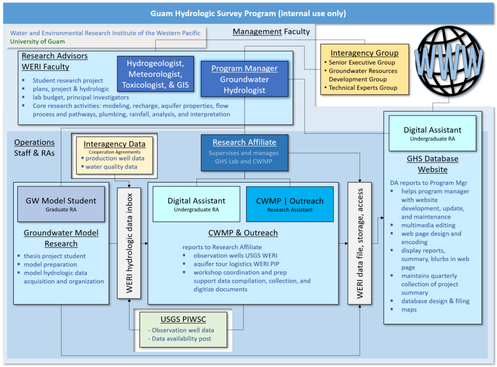
WERI organizes and integrates the GHS and CWMP programs to manage and execute the public law. Below is the WERI personnel organizational chart and each’s duties and responsibilities. The top tier management are WERI hydrogeologist, groundwater hydrologist, and meteorologist. The WERI groundwater hydrologist is the program manager. The research associate reports to the program manager, and is supported by a CWMP student intern.
Groundwater Resources Development Group & Technical Experts Group
WERI is also a member of the local water resource interagency organization called the Technical Experts Group (TEG) and the Groundwater Resource Development Group (GWRDG). The GHS and CWMP mandate requires interagency collaboration and cooperation, as written, “establish a direct working relationship with each organization collecting hydrologic data important to Guam, and maintain a permanent flow of new data from each organization to keep the data library up to date.” Attending local government and federal agencies are Guam Waterworks Authority, Guam Environmental Protection Agency, CUC, US Navy (NAVFAC, Marianas), USAF (CES), and USGS. Our interagency groups also include private consultants: Duenas Camacho and Associates, Allied Pacific Environmental Consultant (APEC), EA Engineering, Brown and Caldwell, and AECOM. Meetings are organized and held quarterly at Guam Waterworks Authority (Gloria B. Nelson Public Service Building), Fadian. Current discussion is the expansion of monitoring (observation) wells, see details in CWMP Research Projects section.
The interagency group is organized in the diagram below. It is formed of three groups: executive, working, working group, and the technical team.
Meet the Team
Web Development
Modeling
Nitrates
Product Development
Information Management
Water Use
Wastewater Treatment
Chlorides
Water Production
Mapping
Web Development
Modeling
Nitrates
Product Development
Information Management
Water Use
Wastewater Treatment
Chlorides
Water Production
Mapping
Past Contributors
GHS Information Management Team Member – Digital Assistant – Web Developer
B.S. Computer Science, University of Guam
WERI, University of Guam
GHS Product Development & Comprehensive Water Monitoring Program (CWMP) – Monitoring System Expansion Rehabilitation Program (MSERP)
M.S. Environmental Science – Presidential Thesis Award Recipient, University of Guam
GHS Web Developer
B.S. Chemistry, University of Guam
WERI, University of Guam
GHS Web Developer
WERI, University of Guam
Co-Operations Manager
PhD, Civil Engineering, Purdue University
Assistant Professor of Water Engineering, WERI, University of Guam
Entomologist
WERI Interim Director: 2022 – 2023
Hydrogeologist
WERI Directory: 2016 – 2022
Appreciation & Recognition
More Than 20 Years Ago Today - 1998
In 1998, Senators Joanne Salas Brown, Tom Ada, and the late Tony C. Blaz of the 24th Guam Legislature, in accord with Water and Environmental Research Institute, University of Guam, determined that our island’s sustainable management of water resources and future development must include interagency cooperation and access to the most accurate and useful hydrologic information through the Guam Hydrologic Survey Program (GHS) and Comprehensive Water Monitoring Program (CWMP) – Guam P.L. 24-247 and P.L. 24-161.
The People of Guam, 24th Guam Legislature, the late Speaker Tony Unpingco, Governor Carl Gutierrez, Committee on Natural Resources, made Guam water information available to everyone. Senate votes: Joanne Brown, Tony Lamorena, Tom Ada, C. Leon Guerrero, Mark Charfauros, Tony Blaz, Antonio Unpingco.
Public Hearing:
Senators: Joanne Brown, Tom Ada, Frank Camacho, and Frank Aguon.
Testimony: Mauryn Quenga, John Jenson, John Jocson, Danko Taborosi, Peter Dumaliang, David Vann, David Dawn, Julianne Duwel, Jesus Salas, and Herbert Johnston.
Memorandums and Statements: Mark Cramer, Galt Siegrist, John Jenson, Julianne Duwel, and John Jocson
34th Guam Legislature
Yearly since, Senator Tom Ada continues to support the island’s hydrologic research, attending WERI’s annual Guam Advisory Council Meeting on water resources and environmental research. In 2015, WERI and Today, the GHS program continues to serve the island as the main source of valuable hydrologic information, most vital for determining protection, sustainability, and best development strategies for our most valuable renewable water resource, the Northern Guam Lens Aquifer. The Northern Guam Lens Aquifer is the most productive source, providing up to 90% of the 45 MGD of utility water. The program has allowed researchers to refine scientific knowledge and develop tools for determining aquifer development.
It has paved way for improved scientific investigations covering various fields of study such as groundwater modeling, hydrogeology, toxicology, wastewater, climatology, sustainable management, hydrologic database, and outreach services. The program allowed data collection, screening, organization, availability and access. Interagency cooperation opened information exchange, which means the best analysis, interpretation, and recommendations. 2018, the 34th Guam Legislature continues to make available your access to the Guam Hydrologic Survey. The GHS Program organizes outreach through workshops and executive aquifer tours.
University of Guam's Good to Great (G2G)
GHS is stationed in the University of Guam, managed at the Water and Environmental Research Institute of the Western Pacific. UOG’s President and Senior Vice President, Drs Robert A. Underwood and Anita B. Enriquez, led the university’s Good to Great (G2G) program, which commands excellence for the University of Guam to serve as the island’s forefront and center of knowledge access and database. The GHS program for the G2G initiative is a “silo buster” through its outreach activities and interagency cooperation services. In 2016 fiber optic internet connection, a robust and very fast information transfer network, were made available throughout the campus. GHS program management takes advantage of this technology to develop this website to provide Guam hydro-informatics “big data” to the world.
GHS UOG Student Success
Outreach Efforts
The GHS outreach program includes the NGLA tour to teach in the field the components of the aquifer. In 2017, WERI, the Guam Water Kids, and Department of Education stop at the DPW quarry to see Barrigada Limestone, which is the rock core that bears much of the NGLA’s freshwater lens. The Guam Water Kids is an outreach program of WERI, managed by Ann and Phil Card, that was funded by Triple J Enterprises and Ford Motor Company Conservation & Environmental Grants.