N. C. Habana, Y. S. Kim, K. K. Bautista, and J. W. Jenson
Guam Hydrological Survey (GHS)
The GHS program management, WERI Director, and Research Affiliate has reorganized the program management to include undergraduate research assistant support. The undergraduate research assistants slot to be filled will assist the program management, supporting web development as GHS mandate part of data repository, access, and distribution. The Research Affiliate will utilize an undergraduate research assistant to manage data and field assistance.
The Guam Hydrologic Survey office and computer hydro-laboratory at WERI had been remodeled to improve GHS functionality. Designated storage space and worktable has been built to organize and prepare valuable field equipment. Workstations and work space have been configured properly for research assistants in the environmental science program. A Guam geologic rock display section was built to improve collection and organization of the island’s rock inventory. This area is also designed as a small geology laboratory.
GHS provides limited stipends for research by graduate students working on their MS degree in Environmental Science and partial summer salaries to WERI faculty advising those students. It also pays for undergraduate field and lab assistants working on water resources projects on Guam, and the salary of one full-time Research Affiliate is charged with operating and managing WERI’s information database, the hydrology laboratory, and preparation and update of routine reports and presentations.
The program activities in this report begins with GHS Research Projects followed by CWMP Research Projects. The GHS section is organized into four sections: Northern Guam Lens Aquifer (NGLA) database, NGLA map series, Sustainable management, and Workshops.
GHS Research Projects
Research projects are grouped into four sections: database, maps, sustainable management, and outreach. The database organizes a borehole database, which is the basis of subsurface information, and a water resources library. It also includes the collection and organization of pertinent meteoric, hydrologic, and water quality data. The maps often summarize the data analysis, and it is truly an indispensable tool for water resource management. Sustainable management is a multi-faceted approach to quality sustainable water resource. The workshops provide training and outreach to our interagency partners.
Northern Guam Lens Aquifer Database
The primary source of facts below the surface of the Northern Guam Lens Aquifer comes from borehole records. Technical Report 141, Bendixson et al., was a major feat in collecting and thoroughly organizing the subsurface factual information. It set a standard means of documenting and placing information in a most simple and logical arrangement. The filing system, table listing, and information categorization is easily updatable. Now, the database is available on the internet for anyone to access (guamhydrologicsurvey.uog.edu, see also the GHS CWMP Online section).
The Guam Hydrologic Survey mandates interagency cooperation with Guam Environmental Protection Agency (GEPA) such that new deep drillings into the aquifer will be properly and thoroughly documented/recorded and submitted the Guam Hydrologic Survey. The cooperation positions WERI to work closely with drillers in assessing the geology and hydrologic potentials in pursuit of optimal production wells. Downhole video is now being used to find the most productive porous media in the borehole to determine the best placement and screening recommendations.
One of the priorities of the PL24-247 is maintenance and routine update of the Guam hydrological database and routine trend analyses of the data. In response, is the ongoing project pertaining to the management and data analyses of the Northern Guam Aquifer Database.
Defining and Evaluating Production Capacity for the NGLA

A numerical groundwater model of the Northern Guam Lens Aquifer (Gingerich, 2013) was used to evaluate the potential capacity of the freshwater lens. 130 vertical wells were simulated within the parabasal zone, the portion of the freshwater lens that is supported by the volcanic basement rather than seawater, in successive average-pumping scenarios from 100 gpm to 500 gpm. Baseline simulation results produced about the same volume of freshwater as the observed system but with a lower overall production weighted average chloride concentration of 44 mg/L compared to 123 mg/L. Successive simulation results show that up to 89 million gallons per day can be extracted from the aquifer while maintaining the production weighted average chloride concentration at 250 mg/L, the safe drinking water guideline set by the Guam Environmental Protection Agency. These results show the advantage of focusing development of carbonate island karst aquifer on the parabasal zone.
Lessons Learned for Well Exploration and Development
Currently, Guam Waterworks Authority (GWA) produces 90% of the 45 MGD potable water from its main source, the Northern Guam Lens Aquifer (NGLA). GWA is currently managing 120 deep vertical production wells in this aquifer to meet the demand. However, many of these production wells are deteriorating from age with more than 40 years in operation, thus lifespan exceeded, maintenance is no longer economically viable, and production has become unsustainable. During the first project year (June 2018 – June 2019), main reasons why production wells had been shut down were analyzed based on the analysis of GWA production well data including 20 inactive wells. Classified main issues are 1) aging, 2) contamination, and 3) water depletion. As of 2018, over 50% of production wells are over 40 years old. Main reasons why production wells had been shut down caused by an aging issue are classified as collapsed well casing, collapsed well screen and pump stuck in well casing. Four production wells have been taken offline due to exceeding maximum contaminant levels (MCL) of chlordane, tetrachloroethylene (PCE) and health advisory levels of perfluorooctanesulfonic acid (PFOS) regulated by US EPA. Two production wells have been shut down due to a water depletion issue. These two wells experienced pumped air during operation.

(1) Aging Issue
Over 50% of GWA production wells are over 40 years old. Main reasons why production wells have been shut down caused by an aging issue are classified as collapsed well casing, collapsed well screen and pump stuck in well casing.

(2) Contamination Issue
Four production wells have been taken offline due to exceeding maximum contaminant levels (MCL) and health advisory levels.
– Chlordane : Well M-14, Yigo-Tumon, basal zone (since 1983)
– PCE : Well A-28, Hagatna, basal zone (since 2006)
– PFOS :Well A-23, A-25, Hagatna, pare-basal zone (since 2017)


(3) Water Depletion Issue
Air was pumped at Well D-22 (Finegayan basin, para-basal) and M-9 (Mangilao basin, basal, but very close to para-basal).
Investigation of Potential PFAS Contamination Sites

Recent UCMR3 results reveal three Guam Waterworks Authority (GWA) production wells to be contaminated with perfluorooctanesulfonic acid (PFOS). One of these wells (NAS-1) is located inside of the former Naval Air Station at Tiyan, in the village of Barrigada. PFOS concentrations found in this well to date range from 67-110 ng/L. The two other wells (A-23 and A-25) are located in Hagatña, one of the oldest villages on Guam. PFOS concentrations determined in both of these wells to date are consistently above 70 ng/L with maximum levels occasionally exceeding 400 ng/L in well A-25. Both wells are currently off-line. Ongoing PFOS source studies have so far identified four potential contamination sites based on historical records and favorable hydrogeological properties of the surrounding area. These sites include: 1) a defective wastewater pump station that leaked millions of gallons of wastewater into the Chaot River over a 25-year period, 2) Agana swamp which drains the Chaot River and where chronic illegal dumping has occurred since WWII, 3) neighboring ponding basins that direct stormwater into the underlying aquifer, and 4) a nearby air flight crash site. Soil/sediment samples were retrieved for analyses of PFOS and other five unregulated perfluoralkyl substances (PFAS) from 22 sampling sites overall. 4.8 ug/Kg of PFOS was detected with the highest level among all sampling sites at one of ponding basins near the Well A-25. 28.29 ug/Kg of six PFASs (sum) was the highest near the GWA wastewater pump station.
Aerial Survey of Landslide Threats in Southern Guam
Tropical cyclones are common to islands in western pacific including Guam and they bring large amount of rainfall within short duration, thereby triggering shallow slope failures/landslides. Accurate modeling of the slope failures resulting from heavy rainfall in mountainous basins, requires spatial-temporal information of temperature and rainfall (meteorological and environmental factors); physical properties, degree of saturation, suction and shear strength parameters (geotechnical and hydrological properties) of soil. Conventional methods of slope stability analyses (saturated and dry soil) do not include the unsaturated soil properties and hence cannot accurately predict the rainfall-induced shallow slope failures. However, accurate seepage and slope stability analyses would require inclusion of unsaturated soil properties.
Two sites are chosen for these studies. First area of study includes slopes in Inarajan watershed along route 4 and is to the North of Tinago river. Second study area includes slopes of Fena reservoir in Fena watershed. Figure 1 clearly shows rainfall induced shallow slope failures in Inarajan watershed of southern Guam. Once the soft low-density topsoil layer supporting the grass/vegetation is lost from slope failure, it is very common that the land turns into badland. Badlands do not support new vegetation and hence the scars remain forever.

Fena valley reservoir is formed by an earthen dam and is located in south central Guam. The dam is a 135-foot-high earth and rockfill embankment founded on deep, young alluvial and lacustrine deposits underlain by well-cemented tuffaceous sandstone and volcanic conglomerate bedrock (Meija, 2017). It is a major source of water supply for US naval base and nearby local villages in Guam. Silting of fena reservoir from excessive sedimentation from side slope erosion and shallow slope failures along streams/rivers is of concern and is the current topic of investigation. During recent field visits to Fena valley reservoir, physical observations by the PI indicated that in general the topsoil layer supports the roots of grass or plantation and is approximately 2-3 feet in depth (Fig. 2). This includes the 1-2 feet depth root zone (Fig. 2). Topsoil layer is underlain by the weathered saprolite layer, finally underlain by deep seated and less permeable volcanic rocks of Umatac formation (Tracey et al., 1964).

Soil samples were collected from top layer supporting vegetation and from underlying saprolite soil layer by driving a steel sampling ring 5 cm height and 2.8 cm in diameter measuring 250 ml volume. Both permeability and SWRC tests were conducted on each sample from Fena reservoir. As expected, the topsoil showed greater saturated permeability than the bottom soil. Saturated permeability of topsoil was measured as 125 cm/day and that of underlying soil was measured as 25 cm/day. Thus, saturated permeability of soil decreased 6-fold while transitioning into bottom soil. Figs 3 and 4 shows the SWRC for topsoil and bottom soil collected from the selected Fena dam site. Van Genuchten model was used to best-fit the experimental points of SWRC. The best fitted SWRC and saturated permeability values were then used to predict the unsaturated permeability of both soils. HYPROP Fit software was used to generate the SWRC as well as hydraulic conductivity fitting curves and functions. Also, the nonlinear variation of unsaturated permeability for both soils with experimental points and fitted predictive equation.


The research team will continue to collect different types of soils encountered in Fena and Inarajan watershed, conduct laboratory tests and the results will be documented. Field instrumentation including rain gage, moisture and suction sensors will be installed at different depths along expected shallow slope failure depths at Fena reservoir site. Data will be collected over a one plus year period and used for slope stability analyses of test slope. Finally, slope stability analyses (numerical simulations) for different rainfall events (corresponding to recent typhoon events) will be conducted on selected slopes and results will be presented with aim to find locations and timings of slope failures/landslides.
Guam Geology Collection and Display
The GHS office laboratory at WERI has included geologic laboratory for basic testing, collection, inventory, reference, and display of Guam’s rocks. WERI is collaborating with one of the island’s most knowledgeable scientist of Guam geology, co-author of the Geologic Map and Sections of Guam, 2007, Dr. Randall. This laboratory is designed to do basic tests and identification analysis under microscope, chemical reaction, and ultraviolet light refraction. The collection shelves more than 50 rock collections from the U.S. (e.g., dolomite, quartz, obsidian, etc.). Dr. Randall will add his collection of prime sample rocks from Guam to add to the inventory. The display shelf organizes 27 rock units by geologic time order. The geologic laboratory is designed to store/shelve field samples, bucket collection, geologic equipment/tools (magnifiers, loupes, ultraviolet light, test chemicals), and geologic reference (literature/publication binder, text books, and geology books). This geologic rock laboratory will be available to the graduate studies environmental science program, outreach education and professional development (workshops), and UOG’s Charter Day activities.
Northern Guam Lens Aquifer Map Series
By far the most important tool for successfully locating site for new wells that will deliver abundant high-quality water from the Northern Guam Lens Aquifer is an accurate and precise map of the aquifer’s subsurface structure and hydrologic components. The updated mapping of the volcanic basement rock that forms the floor of the aquifer was a breakthrough to the developing the Northern Guam Lens Aquifer Map, Vann et al. 2014 (see GHS Trilogy, above). Other ideas have emerged to further improve the mapping of the NGLA.
The Northern Guam Lens Aquifer (NGLA) Map

The volcanic rock beneath the water-bearing limestone partitions the aquifer into semi-contiguous subterranean catchments, or basins. On the slopes of the basement rock standing above sea level, where the base of the aquifer thus lies above sea level, downward percolating fresh water becomes concentrated in basement valleys and at the base of the slopes, where it enters the lip of the fresh water lens. The rim of fresh water thus concentrated along the boundary of the volcanic basement and the water-table near sea level is underlain by volcanic rock rather than sea water. This para-basal water is thus fresher, thicker and much less vulnerable to salt-water contamination than the basal water downstream, which floats on the underlying sea water and becomes progressively thinner and saltier until it discharges at coastal springs and seeps. Water flowing down the flank of the volcanic slopes above sea level, designated supra-basal water, is the freshest of the water in the aquifer and is completely invulnerable to contamination by sea water.The first detailed map of the basement topography was produced as part of the 1982 Northern Guam Lens Study. Beginning in 1998, with the establishment of the Guam Hydrologic Survey by the 24th Legislature, WERI began updating and revising the 1982 map based on new data and insights acquired by exploratory drilling, the emplacement of new monitoring wells, and other data obtained incidental to ongoing local aquifer development and military installation environmental remediation projects.
Most recently, the exploratory drilling program undertaken by the US Navy in 2010 in support of the anticipated military build-up provided additional new control on the elevation of the basement in crucial locations. Moreover, the new Guam Groundwater Availability Study led by the USGS Pacific Islands Water Science Center, in collaboration with WERI, has provided additional funding to update the database that supports the map. An accurate map of the basement topography is an essential prerequisite for building accurate and reliable groundwater models, which is one of the goals of the groundwater availability study.
WERI anticipates publishing a revision of the 2017 NGLA map in 2019. The map consists of a set of superimposed map layers, revealing the basement topography in relation to aquifer geology, hillshade, and the locations of drinking water production wells and aquifer observation and monitoring wells. These maps will be available to other geologists and engineers in the public and private sectors, for which they will enhance the success and thereby reduce the cost of ongoing aquifer development. They will also be essential tools to environmental scientists, regulators, and policy-makers seeking to develop appropriate regulations for aquifer protection and sustainable management.
The Northern Guam Lens Aquifer is Guam’s primary source of water, and if managed properly will continue to supply the island’s daily water needs for generations to come. It is also a very complex hydrogeologic system. No simple technique or approach can characterize this aquifer. Rather, a multi-layer analysis is required to describe, model, and manage the groundwater system. The development of a series of hydrogeologic maps that captures each of the components—while also providing a means for showing their inter-relationships—is of basic and utmost importance for successful exploration, development, and management of the aquifer.
The creation of an up-to-date map of the basement topography (also described in the section, The Northern Guam Lens Aquifer Database) has provided the first step toward an integrated, multi-layered hydrologic map. The new map includes not only updates of the boundaries of the aquifer’s six groundwater basins, but also provides for more accurate and detailed demarcation within each basin of its three groundwater zones: basal, para-basal, and supra-basal. This year’s update incorporates new insights gained from the 2010 Exploratory Drilling Program funded by Naval Facilities Engineering Command Pacific(AECOM Technical Services Inc., 2011), and the 2013 Guam Groundwater Availability Study(Gingerich, 2013; Gingerich and Jenson, 2010).
The new map specifically shows no-pumping simulation from the modeling study to estimate the water-table, hydraulic gradients, flow lines, and basin boundaries. The modeled lens geometry shows the estimated location of boundaries of the para-basal zone. Drill-logs and contours of supra-basal waters(ICF Technology, 1995) were also incorporated in the map. Occurrence of surface streams over the Hagåtña Basin and adjacent terrain were also included. Semi-transparent surface hill-shading provide a surface elevation perspective of the limestone plateau. Other hydrologic features that will be added to the current map or included in complementary maps in the series, include hydraulic conductivities, geologic features, soils, porosities, pumping effects, groundwater locality of sustainable limit supply, land cover, and rainfall distribution.
NGLA Maps: Wastewater Sources and Production Well Nitrates

Development over the NGLA is a concern of possible wastewater contamination. The aquifer’s water resource in a durable karst plateau provides an economic access for development, but the residential and business wastewater discharged above it may be a threat to the freshwater resource. Increased and dense development must be accessed as it may intensify wastewater discharge.
The NGLA map and the layover of the wastewater system provides a useful assessment tool for contaminant transport. It was recently used in the initial assessment of PFOS contaminant source potential. The map may also be used to determine prioritization of sewer systems. The wastewater system map over the NGLA map helps planners strategize future development and reduce wastewater contamination.
NGLA Maps: Drone Imagery of Sinkholes - Vadose Fast Recharge Sites
The first complementary map, which will be published during the coming year, is a map of the sinkholes on the aquifer surface, which constitute its drainage system. Spatial analysis of LiDAR-based digital elevation model allows a precise determination of closed contour depressions on the limestone plateau.
Mapping these depressions and their relationships to other hydrologic and geologic features will be a major contribution to determining the distribution of recharge between fast vertical conduit flow channels and slow percolation through the bedrock. This is important to the refinement for accurately modeling aquifer recharge and potential contaminant entry and flow paths.
NGLA Maps: Drone Imagery of Watersheds, Rivers, and Streams
Proper management of a region’s water resources requires water managers and water resources researchers to have accurate baseline information on the geomorphological and ecological health of surface water streams in a region. It is also vital to have a detailed baseline knowledge of potential pollution sources in groundwater recharge areas. Along with this baseline information there is also a need for periodic sampling of water quality indicators to identify changes in the environmental health of streams and groundwater recharge areas. Studies such as surface and ground water supply studies, depend on this kind of long term variable information to develop the best management practices for a region’s water resources.
In the past, the only means of visual monitoring of stream and groundwater recharge areas health was either with direct on-ground monitoring or the use of high altitude satellite imagery or LIDAR (Light Imaging, Detection, and Ranging) data. This imagery and data was typically accurate to about 0.5-meter resolution. Because of the expense of data gathering, these resources were not available at intervals that could be used for the continued monitoring of the environmental health of Guam’s streams and recharge areas.
Recent advances in commercially available sUAS (Small Unmanned Aerial Systems) technology have made lower cost, highly accurate, sub- meter resolution aerial imagery available. Commercial sUAS drones fly at elevations less than 400 ft., capable of gathering high resolution data used for the development of georeferenced imagery on these low elevation flights. The photographs can be used as detailed high resolution individual photos of streams or groundwater recharge areas or can be composited into highly accurate georeferenced photos of various areas of study. Photogrammetric procedures allow foliage cover removal from the data to develop high resolution composite ground surface digital elevation models of areas of interest.
This project involves Five Phases:
- evaluating and choosing which sUAS drones, cameras and analysis software would be most appropriate for the stream and groundwater recharge study areas
- choosing test stream reaches and groundwater recharge areas to develop the appropriate methodologies for carrying out the aerial data gathering missions
- aerial data gathering and map development
- developing a data management scheme for the imagery and other data gathered using the techniques developed by the project
- continued imagery gathering and processing for various streams and recharge areas on Guam.
Federal Aviation Agency (FAA) no-fly zones, military restrictions, site accessibility, and ownership issues will determine which study areas will be selected. Commercial software such as LiMapper and Drone Deploy will be explored as a means of developing georeferenced imagery and digital elevation models of the areas of interest. The detailed georeferenced aerial data will provide baseline knowledge of the location, size, and potential pollution sources in groundwater recharge areas. In Southern Guam, drone data retrieved will accurately plot stream cross sections, determine erosion potential and possible sediment loading, and other sources of environmental contamination. Data management will use WERI’s and the Island’s Guam Hydrologic Survey website.
Sustainable Management of Guam's Water Resources
Interagency Advisory and Cooperation Group
The sustainable management of water resources is complex that it is more than a hydrologic solution or determination. Ponce (2007) explains that “a holistic approach to groundwater sustainability considers the hydrological, ecological, socioeconomic, technological, cultural, institutional and legal aspects of groundwater utilization, seeking to establish a reasonable compromise between conflicting interests.” He concludes that “sustainability reflects resource conservation policy; the more conservative a policy, the more sustainable it is likely to be.”
WERI is also a member of the local water resource interagency organization called the Technical Experts Group (TEG) and the Groundwater Resource Development Group (GWRDG) establish by the 16 July 2010 Memorandum of Understanding between the US Navy and Guam Waterworks Authority. The MOU provides an additional venue for meeting the GHS and CWMP mandates to “establish a direct working relationship with each organization collecting hydrologic data important to Guam and maintain a permanent flow of new data from each organization to keep the data library up to date.” Local and federal agencies that are party to or affected by the MOU include GWA, GEPA, CUC, US Navy (NAVFACMAR), USAF (36 CES), and USGS. Interagency groups also include private consultants: Duenas Camacho and Associates, Allied Pacific Environmental Consultant (APEC), EA Engineering, Brown and Caldwell, and AECOM. Meetings are organized and held quarterly at Guam Waterworks Authority (Gloria B. Nelson Public Service Building), Fadian. Current discussion is the expansion of monitoring (observation) wells, see details in CWMP Research Projects section. The interagency group organization formed of three groups: executive, working group, and the technical team.
The inter-agency group meets quarterly to discuss concerns, pool resources, share ideas, provide update, consult, and gain professional acquaintance and partnerships. Vangie Lujan of GWA hosts and organizes the group meetings. Here is a list of agencies in attendance:
Government of Guam
GWA – Guam Waterworks Authority
GEPA – Guam Environmental Protection Agency
GCUC – Guam Consolidated Commission on Utilities
GBSP – Guam Bureau of Statistics and Plans
GDPW – Guam Department of Public Works
GPUC – Guam Public Utilities Commission
NGSWCD – Northern Guam Soil Water Conservation District
UOG – University of Guam
GWK – Guam Water Kids
WERI – Water and Environmental Research Institute of the Western Pacific
US Federal
USGS PIWSC – US Geologic Survey, Pacific Islands Water Science Center
NAVFAC Marianas – Naval Facilility Command Marianas, US Navy, Guam
36th CE – Environmental Flight, 36 CE SQ, USAF, Andersen AFB, Guam
Private Sector
AECOM – Architecture, Engineering, Construction, Operations, and Management: Guam Expansion Project
APEC & APDI– Allied Pacific Environmental Consulting, Inc., Allied Pacific Drilling Inc.
B & C – Brown and Caldwell: Essential Ingredients®
DCA – Duenas, Camacho and Associates, Inc.
GHD – Gutteridge Haskins & Davey
IREI – Island Research and Educational Initiative
PCR – PCR Environmental, Inc.
Outreach Programs
Guam Hydrologic Survey provides outreach programs. WERI teams up with Guam Waterworks Authority, Guam Water Kids, UOG Professional and International Programs, for the NGLA Executive Tour and Technical Workshops.
Northern Guam Lens Aquifer Professional Tours

Early 2019, GHS Outreach provided four Northern Guam Lens Aquifer Professional Tours. The tours served two Executive Management and Legislature, Guam Water Kids and Guam Department of Education, and UOG Students. The Executive Management and Legislature tour held two sessions one week apart, inviting senators and representative staff, private sector heads, UOG SVP and Board of Regents, and US Navy Captain Turner and Captain Greene and staff representatives. The third tour was GHS and Guam Water Kids teamwork for Department of Education faculty and the School Program Consultant, for teaching about our water resource. The final NGLA tour was to educate UOG Students – Geography and the School of Engineering’s Society of American Military Engineers. The tour begins with a virtual tour of the NGLA, a computer graphics 3-D hydrology of Guam that allows the audience to see by virtually flying into the aquifer freshwater lens and basement boundaries in the north and the surface water system in the south. It is then followed by a field trip experience of the geologic rocks that make up the aquifer components and an examination of its properties that allow water to move through.
Northern Guam Lens Aquifer Water Resources Workshop
The military buildup and ongoing economic growth anticipated on Guam over the next decade has raised concerns regarding sustainable management of Guam’s groundwater resources. Besides educating policy-makers and agency heads it is also essential that island water resource professionals and educators be equipped with an accurate and up-to-date understanding of the essential characteristics of the island’s aquifer and the factors that must be considered to frame and implement sustainable management practices. Professional people, including working-level technical professionals in the water resource industry, university instructors, and school teachers, have extremely limited time to engage in instructional opportunities. This proposal is for development and delivery of a series of short-course workshops to local water resource professionals and educators. It will include single-day intensive instruction in:
- the Northern Guam Lens Aquifer database and development and use of basement map of northern Guam and
- sinkholes and surface drainage of the aquifer, and salinity trends, patterns, and processes in the aquifer
- the NGLA Tour and 3-D virtual tour of the aquifer, and
- an introductory workshop in basic GIS, presented in six 2-hour sessions, for student researchers, faculty, and professionals working on groundwater and related problems.
- N-baseline report (Rouse et al.)
- Multi-layered NGLA maps (Yuming et al.)
- ENSO
Instruction and media organization will be supported by the GHS website containing the instructional materials plus additional references and links to other relevant and useful resources, and forums for maintaining continuing educational interaction and information-sharing. A new GHS website is underway to accommodate the course resources such as the NGLA database that will be useful for island water developers and managers.
GHS Outreach Support of Guam Water Kids to the Department of Education
The Guam Hydrologic Survey Program and Guam Water Kids (GWK, funded by Triple J Motors) have more than a decade’s worth of teamwork. The Guam Water Kids reaches Department of Education campuses teaching elementary students the value of our water resources and the importance of protecting it. Early 2019, Guam Water Kids and Guam Hydrologic Survey provided a workshop for Southern High School. In one of the GWK workshops, GHS provided a demonstration of freshwater floating on saltwater in a porous media, lecture presentation of water occurrences throughout the island, and the virtual tour of the aquifer.
Comprehensive Water Monitoring Program (CWMP)
The United States Geological Survey (USGS) has monitored our island’s water resources since 1951. Unfortunately, during the 1990s they were forced to downsize this program because matching support from the Government of Guam was discontinued. This resulted in the abandonment of all deep monitoring wells needed to monitor saltwater intrusion in the north, and most of the stream gages in the south by the mid-1990s. In 1995, the USGS closed its field office at Naval Station, but continued to run a limited monitoring program (out of its Saipan and Honolulu offices).

In 1998, the CWMP was made a permanent part of WERI’s program when Governor Gutierrez signed PL 24-161 and PL 24-247. This resulted in the refurbishment of the deep monitoring wells and a renewed program of water resource monitoring on Guam. The intent of PL 24-161 was to restore, and then to expand, as needed, the discontinued monitoring program in order to help Guam manage and safeguard all of its freshwater resources, now and in the future. Under PL 24-161, WERI/UOG and the USGS entered into a memorandum of understanding to administer and fund this program on a 50/50 cost-sharing basis. The CWMP is a permanent investment in Guam’s future.
The loss of a hydrologic observation program has proven to be detrimental. Good hydrologic research studies and support for water management decision essentially require consistent and accurate data. Gaps in data limits a really good analysis and interpretation. This was experienced in the modeling of the NGLA (Gingerich 2013), where more information in the Agafa Gumas basin could have greatly improved the accuracy of the simulation. The interest and value is now well recognized in the GWRDG and TEG in preparation to the expansion of groundwater monitoring, the addition of eight new observation wells.
CWMP Research Projects
The CWMP program collects pertinent hydrologic data and applies analysis and interpretation. The analysis and interpretation is conducted in research projects that will contribute to the status our water resources and new findings. The CWMP program is organized into two components, the monitoring program and data analysis research.
Monitoring (Observation) Programs
The monitoring/observation program is improving. USGS-WERI continues to work as a team in collecting well hydrologic information. The GWRDG and TEG are also currently discussing and preparing for expansion of well observation, installation of eight new observation wells. WERI and GWA established cooperation in a Memorandum of Understanding, where GWA shares the monthly water production report and quarterly well water chloride concentration data. Wastewater-N data is now being logged in two production wells in the Yigo area.
Interagency Cooperation Agreements
Interagency cooperation and knowledge networking is very important and beneficial to our future of sustainably managing our water resources. GWA has a memorandum of understanding with WERI, an agreement to share their production, chloride, and other water quality data. The agreement further strengthens our long history partnership in all efforts to improve water production and wastewater management. Guam Environmental Protection Agency MOU with WERI is soon to follow.
USGS' PIWSC and WERI Observation Well Data Collection
The Comprehensive Water Monitoring Program yields observation well data. The appropriation and acquisition of USGS’ Pacific Islands Water Science Center (PIWSC) and WERI services result in the collection of data for scientific research. It serves as the data source for accurately determining lens dynamics, lens profile terms and definitions, and response to communicative data such as rainfall and tidal signals. It is very useful for frequency analysis of the groundwater lens component position and even groundwater model calibration. The installation of new observation wells will expand the domain with more spatial and temporal data of the lens.
New Deep Observation Wells for the NGLA
The Department of Defense Office of Economic Adjustment (OEA) has granted $3.7 million to the Guam Waterworks Authority (GWA) for constructing and testing seven new deep-monitor wells and rehabilitating twelve existing monitor wells in the NGLA. In January 2017, the GWA selected the engineering consulting firm Brown & Caldwell to lead the Program Management Office (PMO) for execution of the grant. The OEA grant provides critical infrastructure improvements needed to expand the Guam Comprehensive Water Monitoring Program prepared by the U.S. Geological Survey Pacific Islands Water Science Center (USGS) and the University of Guam Water and Environmental Research Institute of the Western Pacific (WERI). In support of the OEA-funded NGLA Monitoring System Expansion Project, WERI and USGS expand and deepen their collaborative work to analyze and interpret new data from the expanded monitoring system and thus provide GWA, GEPA, DoD, and other stakeholders—through an interagency framework—with independent, objective scientific information needed to make informed water-resource management decisions.
NGLA Monitoring System Expansion & Rehabilitation Project (MSERP) launched on October 2017 and will lasts until December 2021. This scope of work is divided into two tasks. Task 1 consists of (1) developing well-construction specifications for seven new deep-monitor wells and rehabilitating 12 existing monitor wells; and (2) defining sustainment requirements for the OEA-funded NGLA Monitoring System Expansion Project and associated expansion of the Guam Comprehensive Water Monitoring Program. Task 2 consists of geophysical logging of the seven new deep-monitor wells to evaluate aquifer properties, especially the characteristics of the water-bearing zones penetrated by the wells.
The role of the USGS and WERI work in Task 1 is to provide GWA and its contractors with technical assistance for constructing and testing new deep-monitor wells, rehabilitating existing monitor wells, and for defining sustainment requirements for the OEA-funded NGLA Monitoring System Expansion Project and the associated expansion of the Guam Comprehensive Water Monitoring Program.
New deep-monitor well construction specifications and technical support: The USGS and WERI work with GWA’s the Program Management Office (PMO) to refine well-construction specifications for seven new deep-monitor wells. WERI provides technical support, including on-site support, before, during, and after construction of the new deep-monitor wells. The PMO will be responsible for ensuring that the driller constructs the wells as designed in the specifications and that the required timelines are met.
Existing-well rehabilitation specifications and technical support: The USGS and WERI will work with GWA’s PMO to refine well-rehabilitation specifications for 12 existing monitor wells. WERI will provide technical support, including on-site support, before, during, and after rehabilitation of the existing monitor wells. The PMO will be responsible for ensuring that the driller rehabilitates the wells as designed in the specifications and that the required timelines are met. The USGS will remove and reinstall water-level recording equipment before and after rehabilitation of existing monitor wells.
Sustainment requirements for the NGLA monitoring program: The USGS and WERI will work together to define permanent ongoing (post-construction) sustainment requirements for the OEA-funded NGLA MSERP and associated expansion of the Guam CWMP. This will include identifying monitoring parameters and frequencies, scheduling and implementing maintenance and recapitalization of the wells, and providing scientific support to include data collection and management, data interpretation, trend analyses, and periodic groundwater modeling updates. These actions are needed to ensure that the OEA-funded infrastructure investments are operated and maintained such that the infrastructure will continually yield high-quality data to support informed water-resource management decisions.

Data Analysis-Interpretation Research
Salinity Patterns and Trends in the NGLA

This project focused on processing, visualization and analysis of the patterns and trends of salinity from drinking wells in the Northern Guam Lens Aquifers (NGLA). Water quality data is available from GWA. GIS is utilized to process and analyze the salinity data, and therefore to locate wells with water quality problems with salinity. Since high level of salinity in drinking water poses risks to man’s health, it is crucial to locate wells with problems with salinity, and archive those wells in a format that permits rapid visualization of spatial and temporal trends of salinity in the wells in the study area using the state-of-art GIS technology. Figure 1 indicates the wells with quality deficiency of high level of salinity. Based on the analysis of the salinity data, and visualization of the locations of the wells with salinity problems, conclusion can be made that most of well with salinity problems are located in Hagatna Basin and Yigo-Tumon Basin, and many located in Finegayan Basin though it is a small basin. Only Well M-9 located in Mangilao Basin was monitored with salinity problem. Figure 2 indicates the salinity distribution based on the result of interpolation of the chloride data collected in the first quarter of 2001. Changes of the trends of salinity can be achieved from time-series data. This technique is especially useful for identifying and predicting subtle long-term trends (increases or decreases) in salinity levels within the aquifer when analyses of salinity data from different dates are provided. The analyses of salinity can provide local government agencies including Guam Waterworks Authority and Guam EPA which are interested in water contamination, particularly salinity problems.
N-data Collection: Phase II
The Northern Guam Lens Aquifer (NGLA) is Guam’s primary source of freshwater for potable use. This porous limestone formation currently provides approximately 80% of the island’s municipal water supply. Aggressive production of groundwater has grown to 40 million gallons per day (mgd). With water demand rising and concerns over water quality increasing, proper management of this freshwater source has become critical to the welfare of the island’s increasing population of residents and tourists. Preliminary inquiries have suggested that contaminants from anthropogenic sources are showing up in the NGLA. Much more baseline data of contaminant concentrations is needed to determine if the problem is greater in zones with sewer collection lines, or in zones that rely on household septic tanks; furthermore, it is not known if contaminant levels are increasing, or not. It is essential that these issues be studied before actions are taken to extend sewer collection lines or even build new wastewater treatment plants in Northern Guam. In addition, the effectiveness of septic tanks is also an issue of concern. As an alternative to traditional septic tanks, consideration is increasingly given to use of single-family prefabricated, packaged treatment units. It is considered that these units could serve to reduce the potential of contamination reaching the water table.

This proposal responds to the critical needs expressed at the Advisory Council Meeting to conduct research on spatial and temporal trends in levels of contaminants in Guam’s groundwater, as well as the need for continuous baseline studies on levels of nitrogenous compounds, etc. with respect to time and location. In addition, it addresses the need for evaluation of innovative wastewater treatment units as alternatives to conventional septic tanks for individual homes, commercial buildings, or hotels.
Methods: Data collection will be done first on selected production wells at representative locations. WERI Technical Report #95 has a map of wells of nitrate trend analysis. Selection criteria include production wells near sewered areas, non-sewered areas, and a combination of both sewered and non-sewered. Multi-probe meters (YSI Inc., Professional Plus) will be used at the selected sites to measure nitrate-N, ammonium-N, pH, temperature, and possibly ORP, atmospheric pressure, conductivity, etc. Data will be imported to a computer for a multi-variate time-series analysis and mapping development.
Objectives: The objectives of this project are:
(1) Data acquisition and literature review of wastewater-N and groundwater-N cycle transformation triggers, and study of groundwater contaminant transport.
(2) Analysis of spatial time-series wastewater-N data at sites with rainfall and other possible influences such as pH, ORP, sewage discharge events, etc.
(3) Translation/interpretation of analysis such as increasing/decreasing trends, averages, and spatial distribution.
(4) Suggest/recommend development strategies to improve wastewater management.
Lens Dynamics

The limestone aquifer of northern Guam supplies more than 90% of the island’s drinking water. The quantity of groundwater available for extraction can be measured in terms of the freshwater lens thickness. Lens thickness can be measured directly from well salinity profiles and inferred indirectly from water levels. The amount of recharge that replenishes the aquifer depends primarily on seasonal and inter-annual changes in rainfall as well as on evapotranspiration, rainfall intensity, and infiltration pathways. Time series data were evaluated in order to determine lens response to recharge and drought. Lag time responses to variations in recharge were determined and can be used as an indicator of lens responsiveness. This project characterizes the response of the lens to natural climate variations, and documents lens and transition zone dynamics driven by both abundant recharge and extensive drought. It will provide an observational baseline against which the accuracy of past, present, and future modeling studies can be evaluated and by which future modeling studies can be reliably parameterized.
The limestone aquifer of northern Guam supplies more than 90% of the island’s drinking water. The quantity of groundwater available for extraction can be measured in terms of the freshwater lens thickness. Lens thickness can be measured directly from well salinity profiles and inferred indirectly from water levels. The amount of recharge that replenishes the aquifer depends primarily on seasonal and inter-annual changes in rainfall as well as on evapotranspiration, rainfall intensity, and infiltration pathways. Time series data were evaluated in order to determine lens response to recharge and drought. Lag time responses to variations in recharge were determined and can be used as an indicator of lens responsiveness. This project characterizes the response of the lens to natural climate variations, and documents lens and transition zone dynamics driven by both abundant recharge and extensive drought. It will provide an observational baseline against which the accuracy of past, present, and future modeling studies can be evaluated and by which future modeling studies can be reliably parameterized.


USGS Deep Observation Data Collection for CWMP
Production wells in the Northern Guam Lens Aquifer (NGLA) are susceptible to saltwater contamination. This project with the Guam Hydrologic Survey continues the process of updating the production well and chloride concentration database for the NGLA. Its purpose is to examine the Yigo-Tumon basin for historical trends and potential influences on salinity. The Yigo-Tumon basin accounts for over half (17 mgd) of the production of the total production (36 mgd) from the aquifer’s six basins. The analysis focuses on natural climate cycles and their relationship to salinity. Chloride concentration in active wells determines extraction limits to municipal water production. Increasing demand may test sustainable limits of the aquifer. This project closely examines natural influence/causes of salinity in production wells in the Yigo-Tumon Basin. We aim to test the hypothesis that seasonality and the El Nino Southern Oscillation have a significant influence on the salinity in the wells.
The Yigo-Tumon basin dataset is of major interest due to the area’s primacy in production volumes and demand. The knowledge gained from this work help to determine and suggest sustainable management practices for municipal water production the Yigo-Tumon basin. Understanding the NGLA response to the seasonal cycle will allow planners to plan new well configurations with greater confidence and to determine appropriate production rates for active wells with the overall goal to maximize production and better understand the risks associated with additional development in the Yigo-Tumon Basin.
There are multiple possible factors influencing the salinity in production wells beyond pumping. The daily tide, typhoons, the wet/dry seasonal cycle, and ENSO all exert their influence on the aquifer. Understanding these influences is critical to the continued sustainable management of a our groundwater resources.

GHS CWMP Online

The GHS and CWMP online is a worldwide access of water resources information and database. The website’s unified resource locator (url) or address is www.guamhydrologicsurvey.com. In the early days of the GHS program, hard copy environmental and water information was stored on the shelves and digital forms in hard drives in several computers managed by the Staff Hydrologist then at the hydrology laboratory at WERI. The GHS mandate requires the consolidation of pertinent Guam hydrologic data into a single computer-based library where information may easily be accessible. In 2010, WERI acquired a server station and developed an intranet of Information Technology tools and hydrologic information. The staff hydrologist then also developed an inhouse server network for each faculty, staff, and student, to store and transfer information. In 2016, the UOG President’s program, Good to Great, aimed at expanding the university’s capacity to make information available to at least interdepartmental level. The easiest solution for this was to create the Guam Hydrologic Survey website via world wide web server, that would reach the world.
This website, in development progress, was first introduced in the GHS workshop, 2016, and the 2016 Guam Advisory Council Meeting and the American Water Works Association (Guam organization).
The workshop trained the members of the Groundwater Resource Development Group and Technical Experts Group, and private consultants. It has also been proven to be a very useful source of information to assist in the rehabilitation of GWA wells in a teleconference with WERI and the contractors APEC and AECOM. The website contains the borehole database (WERI Technical Report 141), borehole database maps, chloride and production database (TR 142). AECOM has referenced the site in its reports. Soon, borehole videos of the rehabilitated wells will be available through the website.
The theme of the GHS website is sustainable management of the island’s water resources. As we face the need for a successful new island development of expansion, upgrade, and rehabilitation, our island’s teams of experts must work together. The GHS website will function as an easily accessible source of knowledge. Sustainable management of our utility water resources requires an understanding of the limitations of our water resources, with respect to all related aspects (e.g., social, economic, hydrologic, geologic). These together will help us determine the proper conservative policies.
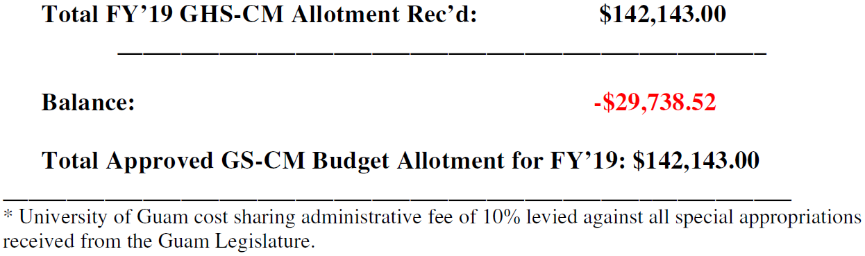
FY 2019 Expenditures for GHS and CWMP
Below is a composite summary of all expenditures lodged against the GHS account during FY’19. As in past years, budgetary shortfalls arising out of austerity measures implemented by the Guam Legislature have so far been covered by carryover funds from GHS allotments received in previous years. As these reserves are limited they cannot be expected to sustain the program at its current high rate of activity for too much longer. This notwithstanding, we gratefully acknowledge the Guam Legislature for their continued interest in and support of the GHS program and all associated water resources related research, education and training activities carried out at WERI.